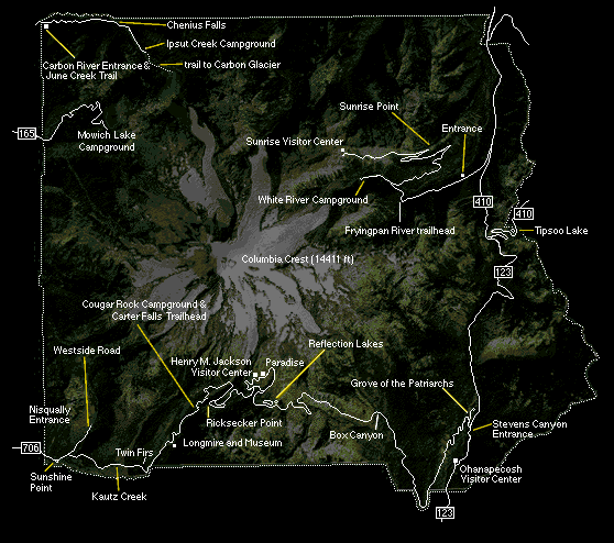
For more detailed maps of the Park click here. The Park web site has extensive information about the Park and its facilities ... worth a visit.
Monday, August 12, 1996
Did my laundry and got a lube, oil and filter done in Yakima then drove on Highway 410 to Mt. Rainier National Park. Highway 410 is a very pretty highway.
Entered the park at the Chinook Pass Entrance and got a campsite at White River campground in the Park and then drove to Sunrise Visitor Center to check it out.
Tuesday, August 13, 1996
I got up early and drove back to Sunrise Visitor Center before the crowds and while the light was good on that side of Mt. Rainier.
Took a bunch of pictures at the Emmons Glacier viewpoint (largest glacier in continental US).
Then did four mile round trip hike to 7008 foot Dege Peak. My fifth peak of the trip (all with trails <grin>).
Found a gal sleeping on top. Great view and took a bunch more pictures.
After lunch some clouds had formed on Mt. Rainier so I went to the Emmons Glacier viewpoint to take a picture, then started walking down another trail intending to go only a short distance.
Ended up doing a five mile hike over Burroughs Mountain.
Didn't have any of the ten essentials with me but fortunately had just finished lunch and tanked up on liquids. Neat hike despite the steep parts of the trail. Great views of the mountain. Lots of people on the trail. A few snowy spots.
Back to White River Campground for the night.

Scene near Chinook Pass Entrance, Pacific Crest Trail trailhead, Mt. Rainier National Park

Mt. Rainier from just inside Chinook Pass Entrance, Mt. Rainier National Park

Mt. Adams from Sunrise Point, Mt. Rainier National Park

Mt. Rainier and Emmons Glacier from Emmons Viewpoint at Sunrise Visitor Center,
Mt. Rainier National Park

Emmons Glacier from Emmons Viewpoint at Sunrise Visitor Center,
Mt. Rainier National Park

Emmons Glacier from Emmons Viewpoint at Sunrise Visitor Center,
Mt. Rainier National Park
Wednesday, August 14, 1996
I headed for Paradise, taking pictures on the way. Clouds sort of obscured the peak by the time I got to Paradise so just checked out the exhibits, etc. then drove down to get a campsite at the Cougar Rock Campground.
Stopped at some view points and at Narada Falls. 168' tall, 3' taller than Niagara Falls according to the sign.
After getting the campsite, drove down to Longmire and looked at the historical buildings, etc. Not too exciting.
The clouds cleared so I drove back up to Paradise and took a bunch more pictures.

Narada Falls 168', Mt. Rainier National Park

Rainbow at Narada Falls, Mt. Rainier National Park

Mt. Rainier & Nisqually Glacier from Paradise Visitor Center, Mt. Rainier National Park

Mt. Rainier Nisqually Glacier from Paradise Visitor Center, Mt. Rainier National Park

Mt. Rainier Nisqually Glacier from Paradise Visitor Center, Mt. Rainier National Park
Thursday, August 15, 1996
Drove down to Ashford to get gasoline and supplies, then back to Paradise. Got delayed twice by long road construction stop, arrived Paradise after noon and set out on the Skyline Trail about 1 p.m.

Trail sign at start of Skyline Trail, Paradise, Mt. Rainier National Park
Trail sign admonishes:
DO NOT: TREAD, MOSEY, HOP, TRAMPLE, STEP, PLOD, TIPTOE, TROT, TRAIPSE, MEANDER, CREEP, PRANCE, AMBLE, JOG, TRUDGE, MARCH, STOMP, TODDLE, JUMP, STUMBLE, TROD, SPRINT, OR WALK ON PLANTS.
Steep climb on paved trail at the start but the close-up views of the mountain and glacier were worth it. Lots of people making the hike.
At one point they provide an alternate route called the High Skyline Trail to bypass a snow field that lasts late into the summer.
This was the case and I'm glad because the High Skyline Trail offered some great views I would have otherwise missed. (might have taken it anyway).
There were four groups of students from the Guide Service going through their training on the snow slopes that blocked the lower trail. Just like ice axe practice for the Basic Mountaineering Course. Brought back old memories.
There were several short patches of snow on the trail but no problems. Most of it is so well constructed for tourists that it's an easy hike. About 6 miles total for the loop.

Mt. Rainier & Nisqually Glacier from High Skyline Trail, Mt. Rainier National Park

Mt. Rainier & Nisqually Glacier from High Skyline Trail, Mt. Rainier National Park
Click for MUCH MORE Mt. Rainier National Park
Got an ice cream cone at the lodge snack bar and drove to White River campground for the night. As late as I was I got the same campsite I'd had earlier in the week. It doesn't have a good place for a tent so most people skip it, but it's great for my white tank.