Saturday, August 22, 1998 (Continued)
Continued south on US 97 and then turned west on US 20 toward the North Cascades. Stopped briefly in Winthrop, WA, then drove to the River Bend Forest Service campground west of Mazama. It was full so I camped in a nearby flat.
Sunday, August 23, 1998
Returned to US 20, then west over Washington Pass and Rainy Pass on the North Cascade Highway down to Marblemount for gas, then on to Baker Lake.
I drove up a logging road that I had found in 1996 to a great viewpoint for the northeast side of Mt. Baker. The view was cloudy and misty when I arrived so I stayed the night (as I had planned to anyway).
Talked to some people from Seattle who had been hiking on a ridge in the area - one couple overnight, the other with two youngsters just on a day hike.
Monday, August 24, 1998
Woke up near first light and got to see the sun light the tip top of Mt. Baker and then work it's way down the snow/glacier slopes. A few clouds drifted about but it was a great morning scene and I got a bunch of pictures.

Northeast side of Mt. Baker, Washington

Northeast side of Mt. Baker, Washington

Northeast side of Mt. Baker, Washington

Northeast side of Mt. Baker, Washington

Northeast side of Mt. Baker, Washington

Northeast side of Mt. Baker, Washington

Northeast side of Mt. Baker, Washington

Waterfalls on northeast side of Mt. Baker, Washington

Waterfalls on northeast side of Mt. Baker, Washington
Headed back down the road about 8:20 a.m. - backtracked to US 20 and headed east on the North Cascades Highway.
Stopped at the North Cascades National Park Visitor Center (which I had skipped in 1996). They have a very interesting set of displays with some outstanding videos built in to each section - four or five in little alcoves so they didn't interfere with each other. They also have a FABULOUS multimedia surround sound show about the Cascades.
I continued east over Rainy and Washington Passes to Mazama, then headed up to Harts Pass. A half mile section of this road cuts across a cliff known as deadhorse point. It has a sheer drop off and is not for the faint of heart. The name comes from the story that in the early days when it was just a cliff hanging trail, some horses panicked and started running and plunged over the side. Read History of Harts Pass area.
I camped at the Meadows Forest Service campground near Harts Pass. Campground was destroyed by a wildfire in 2003 and subsequently rebuilt.
Tuesday, August 25, 1998
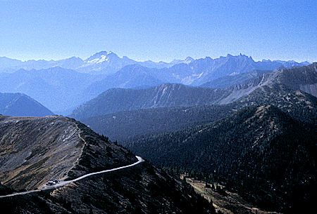
Drove a couple miles to the parking area just below the top of 7,440' Slate Peak and hiked the quarter mile to the top for outstanding views of the North Cascades. The parking area is the highest point you can drive to in Washington.
The road to the peak was built during World War II for a lookout watching for Japanese airplanes. During the cold war it was a radar station.
Now it has a Forest Service fire lookout tower that is only occasionally manned, and some radio stuff.
The top of the three story tower is where the top of the mountain was before they blasted if off to build the radar station.
The clouds had started rising out of the valleys so some of the peaks were obscured.
Silver Star Mountain (left), The Needles (right)
from 7,440' Slate Peak near Harts Pass, Washington

Silver Star Mountain from 7,440' Slate Peak near Harts Pass, Washington
, Tower Mountain (middle left), Golden Horn Mountain (middle right), Black Peak (rear right) from 7,440' Slate Peak near Harts Pass, Washington")
The Needles (left), Tower Mountain (middle left), Golden Horn Mountain (middle right), Black Peak (rear right) from 7,440' Slate Peak near Harts Pass, Washington

Tower Mountain from 7,440' Slate Peak near Harts Pass, Washington

Golden Horn Mountain from 7,440' Slate Peak near Harts Pass, Washington
, Black Peak (center), Azurite Peak (right) from 7,440' Slate Peak near Harts Pass, Washington")
Golden Horn Mountain (left), Black Peak (center), Azurite Peak (right) from 7,440' Slate Peak near Harts Pass, Washington

Azurite Peak from 7,440' Slate Peak near Harts Pass, Washington
, Mount Ballard (right) from 7,440' Slate Peak near Harts Pass, Washington")
Azurite Peak (left), Mount Ballard (right)
from 7,440' Slate Peak near Harts Pass, Washington

Mount Ballard from 7,440' Slate Peak near Harts Pass, Washington

View from 7,440' Slate Peak near Harts Pass, Washington

View from 7,440' Slate Peak near Harts Pass, Washington
 from 7,440' Slate Peak near Harts Pass, Washington")
Snowfield Peak (right) from 7,440' Slate Peak near Harts Pass, Washington
, Crater Mountain (right), Mt. Baker in distance on the right, from 7,440' Slate Peak near Harts Pass, Washington")
Snowfield Peak (left), Crater Mountain (right), Mt. Baker in distance on the right,
from 7,440' Slate Peak near Harts Pass, Washington

Snowfield Peak from 7,440' Slate Peak near Harts Pass, Washington

Mt. Baker from 7,440' Slate Peak near Harts Pass, Washington

Tamarack Peak from 7,440' Slate Peak near Harts Pass, Washington
Backtracked a short distance to a trailhead on the Pacific Crest Trail that skirts around Slate Peak and follows a ridge north.
I hiked out about 1/4 mile beyond Windy Pass on a fine trail with great views of the North Cascades.
Saw evidence of early and recent gold mining activity nearby (near the site of the mining town of Barron).
Met and talked to several other hikers - some hiking this portion of the Pacific Crest Trail.
Enjoyed some fine conversation. 8.2 mile round trip hike - a great day.
Back to Meadows Forest Service campground for the night.
Wednesday, August 26, 1998
Drove about a mile south to another Pacific Crest Trail trailhead and hiked out along the ridge to Grasshopper Pass. I got an early start on this 11 mile round trip so didn't see anyone else until I started back. Great views of the North Cascades and some nearby rugged peaks.
Again talked to some people hiking this section of the Pacific Crest Trail and also two local couples from Mazama/Winthrop. One couple had two boys in the Navy at San Diego and they were familiar with the Bishop/Mammoth Lakes area - even Lone Pine - and the Los Angeles Aqueduct water story. They also explained the haze that looked like smoke - it was smoke, from a fire near Lake Chelan. Fortunately it didn't mess the scenery up except a little to the east.

Tower Mountain and Golden Horn Mountain from Grasshopper Pass

Azurite Peak from Grasshopper Pass

Azurite Peak from Grasshopper Pass

Unidentified Peak from Grasshopper Pass

Unidentified Peak from Grasshopper Pass

Mount Ballard from Grasshopper Pass
Back to Meadows Forest Service campground for the night.
Thursday, August 27, 1998
Awoke to a beautiful clear day so drove back to Slate Peak. The sky was clear so I got some great views and pictures. Could see snow/glacier clad Mt. Baker rising to the west.
Headed back down the road past deadhorse point and drove into Winthrop to get some supplies and convert my Canadian money back to US. Then I returned west to the Lone Fir Forest Service campground just east of Washington Pass for the night.

Friday, August 28, 1998
Drove over Washington Pass with fine views of the west side of Liberty Bell Mountain and the Early Winter Spires to the Blue Lake trailhead and did the 4.4 mile round trip hike to beautiful Blue Lake.
 and Liberty Bell Mountain (right) from highway to Washington Pass")
Early Winters Sphires (left) and Liberty Bell Mountain (right)
from highway to Washington Pass
 and Liberty Bell Mountain (right) from highway to Washington Pass")
Early Winters Sphires (left) and Liberty Bell Mountain (right)
from highway to Washington Pass

Cutthroat Peak on the northwestern side of North Cascades Highway from Blue Lake trail
At 6254 feet, Blue Lake sits quietly a little over two trail miles from Highway 20. With towering granite peaks, forests, meadows, wildflowers, and of course the beautiful mountain lake surrounded by granite that reaches for the sky, this short hike is easily a classic.
 and Early Winters Sphires (center) over Blue Lake, North Cascades Highway")
Liberty Bell Mountain (left) and Early Winters Sphires (center) over Blue Lake, North Cascades Highway
 and Early Winters Sphires (right) over Blue Lake, North Cascades Highway")
Liberty Bell Mountain (left) and Early Winters Sphires (right) over Blue Lake,
North Cascades Highway

Blue Lake outlet, North Cascades Highway

Blue Lake outlet, North Cascades Highway

Blue Lake outlet, North Cascades Highway
Then I drove to Rainy Pass and took the 2 mile round trip paved trail to Rainy Lake. Nice nature/handicapped trail to the lake which is not a particularly great lake but does have some waterfalls. Unfortunately the light wasn't very good for pictures.
I then headed east again through Winthrop to Twisp and up the Twisp River to Roads End Forest Service campground where I had camped several nights in 1996. It was much cooler up here than down in town.
Saturday, August 29, 1998
Drove back to Twisp, got gas and some supplies, then headed south back to US 97. Today was just a travel day, going south on US 97 with no sight seeing. I've seen about all the museums and such I can stand for this year <grin>. It was HOT and HAZY in the Columbia River canyon and across the dry country east of the Cascades. I was sure glad to have great air conditioning in my traveling house.
Mt. Jefferson, Mt. Washington and the Three Sisters poked they heads high in the sky through the haze as I drove into Redmond, OR just north of Bend. I spotted a new Motel 8 so stopped for the night.
Sunday, August 30, 1998
Continued south on US 97, then turned west and drove to Crater Lake National Park.
In 1996 I had visited the park in June and the east rim road was closed by snow.
This time I was able to drive the east rim and get all the great views from that side.
The lake is still as BLUE as ever and it was a beautiful day.
Spent the night at the park campground.

Crater Lake, Crater Lake National Park, Oregon

Wizard Island on right with The Watchman and Mt. Hillman above, Crater Lake, Crater Lake National Park, Oregon

Dution Cliff, Applegate Peak, Garfield Peak, Wizard Island, Crater Lake, Crater Lake National Park, Oregon
Click for more Crater Lake National Park
Monday, August 31, 1998
Headed south for home. Drove down to Klammath Falls, OR, then into California and on Highway 139 to Susanville, CA then on via US 395 arriving home at 6 p.m. - a beautiful day. Glad to be home after 78 days (eleven+ weeks), about 14,400 miles and 2,000 pictures.
It was a great trip, no problems, no illness, generally good weather and lots of great scenery and history.


