11,499' San Gorgonio Mountain, the highest peak in Southern California is in the San Gorgonio Wilderness and can be reached by a number of different routes. It is a popular area and is heavily traveled in the summer. It is an excellent spring and fall trip when allowance is made for the prevailing weather. Winter provides excellent snowshoe or ski tour trips with proper equipment and training. The best snow is usually during February and March. Details of routes we used were found in the guide book "SAN BERNARDINO MOUNTAIN TRAILS" by John W. Robinson, Wilderness Press which is available here.
Since I did these trips with friends, Explorer Post 360 and the Sierra Club there have been many changes which control access to limit overuse. See the Regulations here. Wildfires have damaged many areas.
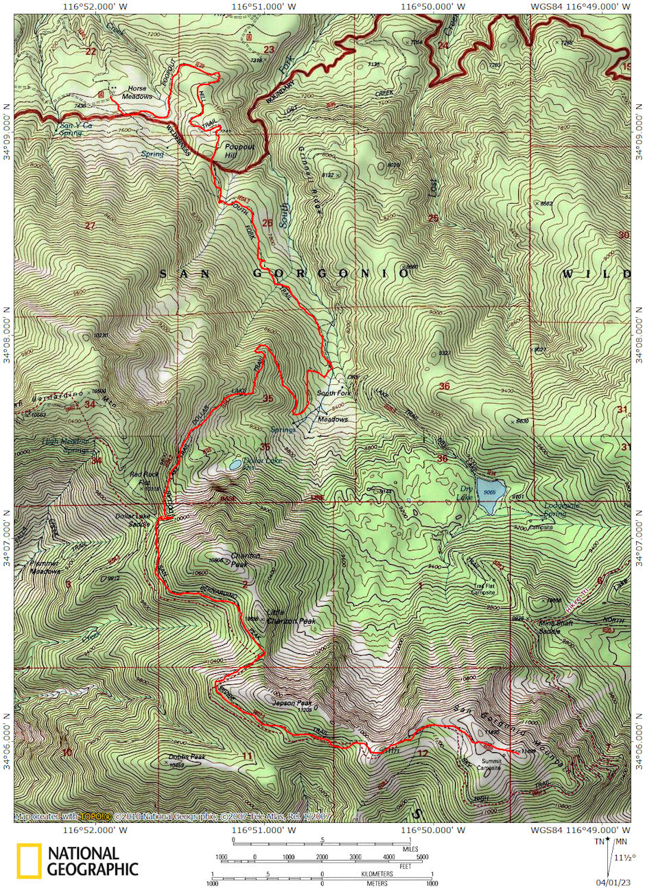
The Poop Out Hill trailhead that we used to take the South Fork Trail is no longer available. The road to it is now closed to the public. The South Fork Trail now starts about 2.5 miles lower down and is described here which includes printable maps. The Vivian Creek trailhead which we also used is still available as described here including printable maps. Those links give you access to other routes in the area. Click here for a lot of trail information on the San Gorgonia Wilserness Association website.
This peak is part of the "9 Peaks Challenge"Wilderness Permits are limited and require that you use designated campsites as shown on your permit. More information here.

San Gorgornia Mountain South Fork Trail Map
I hiked to the peak as follows:
Date:
July 2-4, 1958
March 14-15, 1959
March 21-22, 1959
September 19-20, 1959
November 27-28, 1959
March 26-27, 1960
December 18, 1960
February 25-26, 1961
April 15-16, 1961
June 24-25, 1961
October 21-22, 1961
February 24-25, 1962
July 7-8, 1962
March 16-17, 1963
March 30-31, 1963
March 7-8, 1964
October 23-25, 1964
March 20-21, 1965
September 26, 1965
November 5-7, 1965
March 26-27, 1966
October 22-23, 1966
October 27-29, 1967
March 23-24, 1968
October 5-6, 1968
March 14-15, 1970
November 27-29, 1970
October 23, 1972
March 10-11, 1973
Party:
Solo (first ascent)
Post 573 - to old ski hut, no peak
Post 360 - to old ski hut, no peak
solo - to Dry Lake, no peak
Post 573 - to Dollar Lake and peak
Post 360 - peak via snow
Friends - Vivian Creek trail exploratory
Post 360 - peak via Vivian Creek trail
Sierra Club - peak via Dollar Lake
Solo - Dry Lake, Lodgepole Spring, Fish Creek, 10,000 foot ridge, Dry Lake/N.
Fork Meadow Saddle, peak(camped on top), Jepson Peak, High Meadow Spring
Post 360 - peak, Charlton, Andersen, East San Bernardino
Post 360 - Barton Flat road to Poopout Parking
Sierra Club - peak and Charlton Peak
Post 360 - to old ski hut site, no peak
Post 360 - to old ski hut site & peak, icy
Post 360 - to old ski hut site, 2' fresh snow
Post 360 - 9 Peaks Award (Vivian Ck. Road head at 10 pm, moonlight 5 miles to
High Creek at 1:15 am; 13 miles for 6 peaks to Trail Fork Springs from 9:30 am to
6:30 pm; 12 miles for 3 peaks to Camp Angelus from 9:15 am to 2:15 pm)
Post 360 - peak via snow
Friends - Falls Creek trail to within 1 1/2 of peak
Post 360 - 9 Peaks Award (See October 23-25, 1964 trip - 10 pm-1:05 am; 9:30
am-6:30 pm; 8:30 am-1:45 pm)
Post 360 - snow trip, no peak
Post 360 - High Meadow Spring, peak, Sky High Trail
Post 360 - 9 Peaks Award - See October 23-25 trip
Post 360 - snow trip, peak, beautiful weather
Post 360 - via Sky High Trail, peak camp
Post 360 - snow trip, peak, beautiful weather
Post 360 - 9 Peaks attempt-stopped by ice
Don Deck & Karl Kohagen - new Fish Creek Trail to Mineshaft Saddle
Don Deck, Paul Robatta, George Brady, Brian Twohey - from Forest Home
up Mill Creek Canyon on snowshoes from roads end (6000') to pass at head of
canyon (8400')
Miles
18
8
8
7
18
11
8
18
18
22
20
5
21
10
15
10
30
15
17
30
10
20
30
15
18
21
14
10
7
