Mount Langley is a mountain located on the crest of the Sierra Nevada, on the boundary between Inyo and Tulare counties in eastern California. To the east is the Owens Valley, and to the west is the Kern River Valley. It is the ninth-highest peak in the state and the seventh-highest in the Sierra. Mount Whitney, the highest peak in the contiguous United States, lies 4.8 miles to the northwest. Mount Langley also has the distinction of being the southernmost fourteener in the United States.
Historically the mountain has had several names. Today, the mountain is named after Samuel Pierpont Langley. In the early 1870s, it was confused with Mount Whitney by early climbers, and called by that name. When the mistake was realized, the peak was alternately called Mount Corcoran, Cirque Peak, or Sheep Mountain; the former two names being later attached to other mountains. But its current name became established in local usage, and was made official by the Board on Geographic Names in 1943.
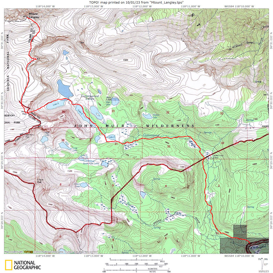
Mount Langley is one of the easiest of California's fourteeners to climb. A hiking trail starts at nearby Horseshoe Meadow, at an elevation of about 10,000 feet, passes scenic Cottonwood Lakes, and climbs through New Army Pass. From there hikers travel cross-country to Old Army Pass, where they may pick up the route to the peak.
At the time we climbed it, there was no maintained trail leading to the top of Mount Langley. Over time, hikers created a variety of routes, resulting in over 10 miles of ruts and tracks that damaged fragile alpine plants, soils, and bighorn-sheep habitat.
To reduce these impacts, the National Park Service has established the Mount Langley Trail to the summit and removed nearly 8 miles of braided, incised informal trails. The new formal trail follows one of the previous informal trails; it has not been improved or constructed. However, workers placed a series of rock cairns to mark this preferred trail and to guide hikers.
The trail from the road trailhead starts in the John Muir Wilderness. When you cross New Army Pass or Old Army Pass you enter Sequoia National Park for the two mile climb to the peak. New Army Pass is 7 miles from the trailhead at Horseshoe Meadow and is an easier but longer approach to Langley than Old Army Pass via Cottonwood Lakes Trail.
Due to the elevation, both passes are covered with snow most of the year. New Army Pass sits on a south-facing slope and it tends to clear of snow somewhat earlier in the season. Old Army Pass is only clear of snow for less than two months per year, from mid-August to early October. During the winter months the paved road to Horseshoe Meadow is closed.
The first recorded climb of the mountain was in 1871 by Clarence King and the French mountaineer Paul Pinson.
With Explorer Post 360 I attempted to climb 14,042' Mount Langley twice.
The first trip was on July 14-16, 1967 on a 20 mile round trip via Little Cottonwood Lakes with myself, Gordon Lee, Jim Polak, Roy Wagner, Wendell Stewart, Bill Jennings, Steve Henderson, John Lee, Brian O'Leary, Don Fife, Chris Skinner, Paul Davis, Guy Acheson, George Davidson, Fred Nicolet, Noel Parr, Bob Johnson, Ricky Johnson, Norm Hewitt and Rick Remington.
We arrived from San Diego at the Little Cottonwood Creek roadhead and to bed about 1 a.m. Friday night. Beautiful road. Up at 6 and on the trail by 8 a.m. Saturday. Beautiful hike area. Light to medium rain during hike. Off and on rain during afternoon and evening. Camped at 11,000' #3 Cottonwood Lake.
Sunday weather kept us from going to Mount Langley - instead, 7 of us climbed Old and New Army Passes (12,000')- beautiful snow climb up Old Army Pass. This is the way to go for Langley - could see lots of Sierra and lots of snow on peaks. Could see Whitney from New Army Pass.
Left camp (after glissading down the pass) at 1:30 p.m. as it started to hail - some as large as marbles. Arrived at cars at 5 p.m. and home in bed at 12:30 a.m.
The second trip was on July 19-21, 1968 on an 18 mile round trip via main Cottonwood with 28 people. The road, which had been under construction on the first trip, was now open to its end at Cottonwood Creek where we arrived by midnight and camped out.
We were up and on the trail about 7:30 a.m. Hiked nice 6 miles up Cottonwood Creek to Cottonwood Lake #4 and made camp and checked out the route.
Sunday we were up at 5:15 a.m. and on trail by 7 a.m. Eleven (9+2 guests) of 14 make the peak - easy terrain - altitude biggest problem. On the return to road Doug Ruth got sick and was brought out on a horse from Golden Trout Camp. This delayed departure from 4:30 to 6 p.m. but still made it home in good time. Good trip.

Mount Langley climbing route 1967 and 1968
Detailed route description by another party to Mount Langley with pictures and map.
Another detailed route description by another party to Mount Langley with pictures.
