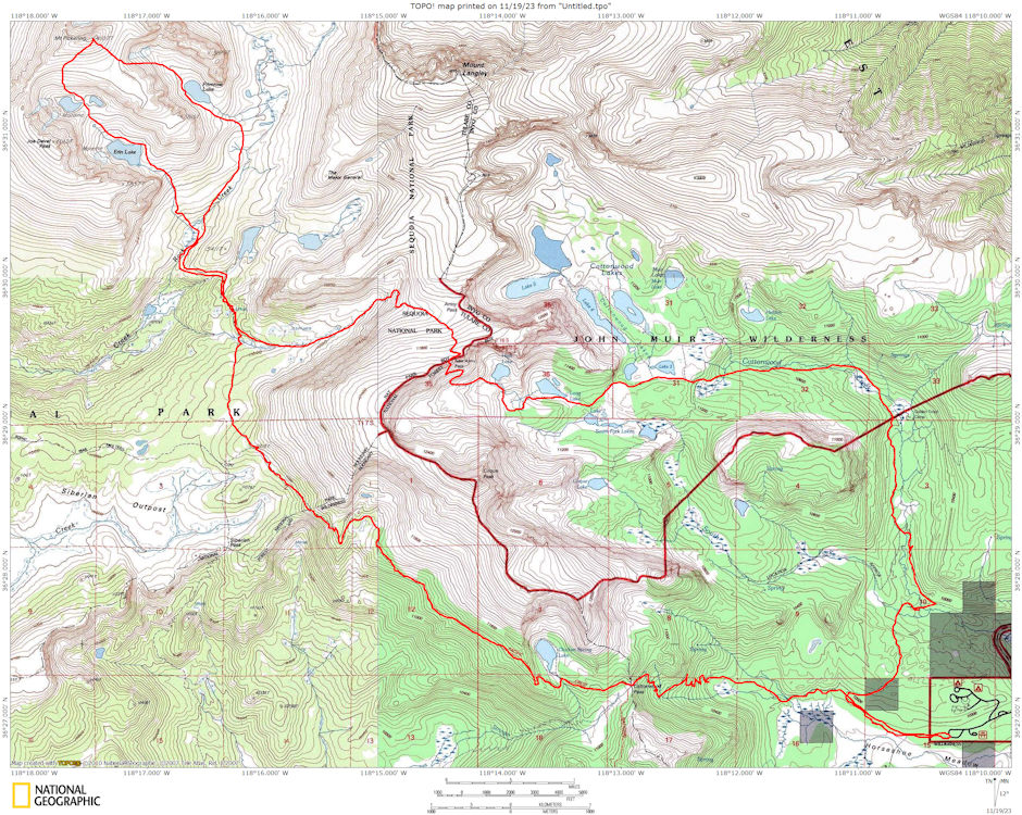
On July 3-5, 1976 I took a 28 mile round trip backpack to 13,485' Mount Pickering with Gil Beilke, Roger Getz, Gordon Lee, Lisa Sternberg, Ellie Heston, Bob Johnson and Jan Johnson.
Mount Pickering is a 13,485-foot-elevation mountain summit located just west of the crest of the Sierra Nevada mountain range in Tulare County, California. It is situated in Sequoia National Park, and is 3.1 miles south of Mount Whitney, 1.2 mile southeast of Mount Chamberlin, and one mile south of Mount Newcomb. Mount Pickering ranks as the 65th highest summit in California. Topographic relief is significant as it rises nearly 2,000 feet above Sky Blue Lake in approximately one mile.
This mountain's name was proposed by the Sierra Club and officially adopted in 1940 by the U.S. Board on Geographic Names to honor American astronomer Edward Charles Pickering (1846–1919). The immediate area has other geographical features named for astronomers, including Mount Newcomb, Mount Langley, Mount Young, and Mount Hale. The first ascent of the summit was made July 16, 1936, by Chester Versteeg, Tyler Van Degrift, and Oliver Kehrlein.
We all gathered at the Horseshoe Meadows trailhead about 6 a.m. on Saturday. Gil and Roger headed with packs for Cirque Peak with plans to meet us at camp at a lake near the Major General. The rest of us headed for camp via Cottonwood Pass. We hit the trail about 7:30 and made good time in spite of a few foot problems.
We had a lunch stop early on Cottonwood Pass and again near Siberian Pass. We found a new section of the Pacific Crest Trail in Sequoia National Park which by-passed Siberian Pass and intersected that trail further north.
We met Gil and Roger at the Army Pass Trail junction about 5 p.m. and quickly made the final mile into camp. After supper Roger and Gil climbed The Major General. We hit the sack at various times.
Gil started things moving about 5 a.m. Sunday and he and Roger set out via a long round trip up Perrin Creek to climb Mt. Chamberlin and Mt. Newcomb. They climbed Chamberlin and decided against Newcomb due to the route and time - got back about S p.m.
Gordon, Bob and I set out about 8 a.m. for Mount Pickering. We crossed the low ridge north of camp and headed up past Erin Lake to the lakelet between Joe Devel and Pickering, then up the rock and sand slope to Pickering - arriving about 2 p.m.
We spent an hour and a half on top enjoying great views. (It turned out that a Birthday Party for America by Mike Cassiday, Dorian I., and Cody Christensen complete with cake, 200 candles, and horns, streamers, etc. commenced about 3 p.m. on top of Whitney).
About 3:30 we headed down via Primrose Lake - encountering one tricky section off the plateau SW of Pickering. Primrose would make a neat campsite. We dropped into the Rock Creek basin and contoured around and over the ridge back to camp about 6 p.m.
Monday, Gil got us up at 5 a.m. again and got himself, Roger and Gordon on the trail about 6 a.m. The rest of us left about 7 a.m. except Lisa who continued on four more days of backpacking to end with a climb of Mt. Whitney. We went out via New Army Pass and reached the car about 1:45 p.m. complete with sore feet and a few blisters. Outstanding weather - a great trip.

Route map to Mount Pickering 1976
