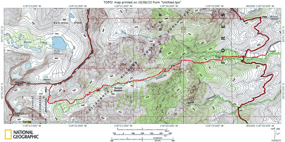
The Baxter Pass Trail provides access to the John Muir Wilderness. It climbs more than 6,000 feet to Baxter Pass, on the Sierra Crest. The trail continues into Kings Canyon National Park, where it joins the John Muir Trail. Baxter Pass Trail is steep and rugged. In some places it is difficult to locate. It is in the California Bighorn Sheep Zoological Area. I was able to get some pictures of them on my 1977 trip.
From Highway 395, approximately 2 miles north of Independence, California turn West onto Fish Hatchery Road. Turn right onto North Oak Creek Road at the fork about 1 mile from the highway. The Baxter Pass Trailhead is at the end of North Oak Creek Road, about 5 miles from Highway 395.
The trailhead is at about 6,000 feet. It is a steep climb to the alpine basin of Summit Meadow at about 11,000 feet. This is steep country, but it’s also in the heart of the Sierra, with classic views and great flora and fauna. I visited the area three times.
The first trip was a 21 mile round trip backpack on June 20-21, 1970 with myself, Gil Beilke, John Webster and Uel Fisk.
We were up at dawn at the roadhead in a swarm of bugs and headed up the long trail to summit meadow. We made made 5,000 feet in 6 hours. Left the cars at 5:45 am and made Summit Meadow at 11:45 a.m. Took 1 hour for lunch then on to Baxter Pass.
We camped at a lake 400 feet below the pass (not on map). Gil and John climbed Black Mtn and returned to Summit Meadow on Saturday. They came over Baxter Pass on Sunday morning and climbed Baxter Peak while I climbed Baxter Col. Great views on Baxter slopes. Returned to camp by 1 p.m. Left at 1:30 and arrived at the cars at 4:30 pm. Home 11:30 p.m. Great weekend.
The second trip was a 12 mile round trip backpack on April 15-16, 1972 with myself, Gil Beilke, Roger Getz, Karl Kohagen and Jim Bloom.
I hiked only to camp at about 10,800 on Baxter Creek. Gil, Roger and Karl climbed Diamond Peak on Saturday. Gil, Roger and Jim attempted peak 13,070 on Sunday but ran out of time for difficult terrain.
The third trip was a private ten mile round trip backpack on October 8-9, 1977.
I Hit the trail shortly after 8 a.m. on a beautiful warm fall day - great hiking weather. Took it fairly leisurely. Stopped for lunch and rest about 11 a.m. at the third creek crossing.
After the next flat just before a steep section I ran into five Bighorn Sheep coming down the trail. I stopped, got out my 300MM lens and tripod and took pictures. Managed to get within l00yards before they decided to move out on me.
I continued to the next flat for rest and snacks, then on to the "meadow" area near the creek fork before turning up toward the pass. There was light snow in the meadows and elsewhere so I found a camp site in a sunny level spot on a rocky bench about 4:30 p.m.
The sun disappeared behind the mountain and it cooled off quickly. I made supper and hit the sack about 7 p.m. Pleasant night - never got really cold although it probably barely froze. Camp was at 10,800.
Next morning I waited for the sun to hit the tent around 8:30 a.m. and got up, fixed breakfast and headed up toward the pass. Passed a dead horse and stopped about half way to the pass. Decided to return to camp and home since I had my sheep pictures and seemed to have a head cold (or allergy??), Headed down the trail about 1:30 and reached the car about 3:30 or so (I think??). Was a nice hike down. Nice trip.

Baxter Pass Trail Route Map
