On August 29-September 7, 1970 myself, Gil Beilke, Gordon Lee, Richard Alvernez, Tim McSweeney, Roger Getz, Dale Caldwell, Russ Boelhauf backpacked into the Sixty Lakes Basin. See the approximate complete trip route at the bottom of this page.
From the Onion Valley trailhead we backpacked up to Kearsarge Pass, then on the high trail just past the trail down to the Kearsarge Lakes to the site of the no-longer used summer Kearsarge Ranger Station for the night. The next day we headed up toward Mt. Gould. I believe we found portions of the abandoned Dragon Lakes trail. At some point we headed directly for the top of Mt. Gould on class 1 terrain with a short class 3 summit block.
We saw climbers on top of nearby Dragon Peak. After spending time on the top of Mt. Gould we dropped down to the old trail and followed it to the Rixford/Gould Pass. The route down from the pass to the Dragon Lake drainage is a steep scree & talus slope - loose rock biggest problem. We found an abandoned mule pack saddle, well aged.
Mt. Gould (13,005') is a thirteener on the Sierra crest, just north of the Kearsarge Pass. Mt. Gould's north-south ridge straddles the boundary between Fresno County and Kings Canyon National Park to the west, and Inyo County and the John Muir Wilderness to the east. Its western slopes drain to the Kings River, and its eastern slopes feed the Owens River. Its nearest neighboring peaks are Dragon Peak to the north, Mt. Rixford to the west, and Nameless Pyramid to the south across Kearsarge Pass.
There are several class 1 routes to the top. The first recorded ascent was on July 2, 1890 by Joseph N. LeConte, Hubert P. Dyer, Fred S. Pheby, and C. B. Lakeman. They called it University Peak. They scrambled the talus of Gould's south ridge, and climbed the more solid rock of its summit block. This route, by way of the Kearsarge Pass Trail from the Onion Valley trailhead, remains the easiest and most accessible approach.
In 1896, LeConte and a party climbed a higher peak, 2.4 miles to the south, to which he transferred the name, University Peak. The next day he led a second climb of Mt. Gould and named it for his companion, Wilson S. Gould.

Signing the register on top of Mt. Gould
Kings Canyon National Park 30 Aug 1970

Kearsarge Lakes and Pinnacles from top of Mt. Gould
Kings Canyon National Park 30 Aug 1970
Junction Pass and Peak (upper left), Forester Pass, Kearsarge Pinnacles and Lakes, Mt. Brewer, Bullfrog Lake from top of Mt. Gould
Kings Canyon National Park 30 Aug 1970
, North Guard, Bullfrog Lake (lower right) from top of Mt. Gould<br>Kings Canyon National Park 30 Aug 1970")
Mt. Brewer (left), North Guard, Bullfrog Lake (lower right)
from top of Mt. Gould - Kings Canyon National Park 30 Aug 1970

Bullfrog Lake from top of Mt. Gould
Kings Canyon National Park 30 Aug 1970

University Peak from top of Mt. Gould
Kings Canyon National Park 30 Aug 1970

Junction Peak from top of Mt. Gould
Kings Canyon National Park 30 Aug 1970

Mt. Brewer from top of Mt. Gould
Kings Canyon National Park 30 Aug 1970

Climbers on top of Dragon Peak from top of Mt. Gould
Kings Canyon National Park 30 Aug 1970
Beautiful country descending to Dragon Lake.

Descending to Dragon Lakes and Rae Lakes
Kings Canyon National Park 30 Aug 1970

Lakes of Dragon Lake basin, Rae Lakes
Kings Canyon National Park 30 Aug 1970

Rest stop at lake above Dragon Lake
Kings Canyon National Park 30 Aug 1970

Flowers near Dragon Lake
Kings Canyon National Park 30 Aug 1970

Flowers near Dragon Lake
Kings Canyon National Park 30 Aug 1970

Gil Beilke examining decomposing granite
Kings Canyon National Park 30 Aug 1970

Descending to Dragon Lake
Kings Canyon National Park 30 Aug 1970

Colorful Dragon Lake country
Kings Canyon National Park 30 Aug 1970

Dragon Lake
Kings Canyon National Park 30 Aug 1970
August 30, we made camp at Dragon Lake.

Dragon Lake, Mount Clarence King
Kings Canyon National Park 30 Aug 1970

Dragon Lake
Kings Canyon National Park 30 Aug 1970
From Dragon Lake we proceeded west across the Rae Lakes to the "Notch" south of Fin Dome on our way to 60 Lakes Basin. We stopped and climbed Fin Dome - tremendous views.

Painted Lady from below Dragon Lake
Kings Canyon National Park 31 Aug 1970

Painted Lady and Glen Pass from below Dragon Lake
Kings Canyon National Park 31 Aug 1970

Painted Lady, Glen Pass, Rae Lake - Kings Canyon National Park 31 Aug 1970

Mount Cotter, Fin Dome, Mount Clarence King, Rae Lakes
Kings Canyon National Park 31 Aug 1970

Mount Cotter, Fin Dome, Mount Clarence King, Rae Lakes
Kings Canyon National Park 31 Aug 1970

Painted Lady, Rae Lake
Kings Canyon National Park 31 Aug 1970

Young fishermen at Rae Lakes
Kings Canyon National Park 31 Aug 1970

Painted Lady, Rae Lake
Kings Canyon National Park 31 Aug 1970

Don Deck, Fin Dome, Rae Lake
Kings Canyon National Park 31 Aug 1970

Rae Lake - Kings Canyon National Park 31 Aug 1970
Fin Dome is a thin blade of granite found in the heart of the Kings Canyon National Park Wilderness. It rises from the ridge separating Sixty Lakes Basin from Rae Lakes, standing as a sentinel and seen by hundreds of hikers each year as they make their way along the John Muir Trail in its vicinity. Only a handful of those that see it come to climb it.
Named by Bolton C. Brown in 1899. On a sketch map he depicted the features between Rae Lakes and Sixty Lake Basin (neither of those yet named at the time) as a south-facing monster: "The Sea Serpent." Of the names of the serpent's parts, "The Fin" is the only one that stuck. What Brown called "The Head" is the feature with an unchecked elevation of 11,942 feet. "The Tail" was the long ridge running north from Fin Dome.
The easiest route to its summit is the circuitous and challenging class 3 West Face. The South Ridge and North Buttress are rated class 4, but these are far more difficult than what would be considered class 4 by today's standards. Several noteworthy class 5 climbs have been established on the steeper east side, in particular the 5.7 East Face first climbed by Galen Rowell and Marek Glogoczowski in 1972.

Rae Lakes from Sixty Lakes Trail
Kings Canyon National Park 31 Aug 1970

Fin Dome - Kings Canyon National Park 31 Aug 1970

Fin Dome - Kings Canyon National Park 31 Aug 1970

In back - Dale Caldwell, Richard Alvernez; In front - Don Deck,
Tim McSweeney, Roger Getz, Gil Beilke on top of Fin Dome
Kings Canyon National Park 31 Aug 1970

Gil Beilke, Dale Caldwell, Roger Getz, Richard Alvernez
on top of Fin Dome - Kings Canyon National Park 31 Aug 1970

Richard Alvernez, Dale Caldwell, Gil Beilke, Tim McSweeney check the map
on top of Fin Dome - Kings Canyon National Park 31 Aug 1970
 from top of Fin Dome<br>Kings Canyon National Park 31 Aug 1970")
Rae Lakes, Dragon Lake (on left behind ridge) from top of Fin Dome
Kings Canyon National Park 31 Aug 1970

Dragon Lake from Fin Dome
Kings Canyon National Park 31 Aug 1970

The chute down from Mt. Gould saddle to Dragon Lake from Fin Dome
Kings Canyon National Park 31 Aug 1970

Rae Lakes from Fin Dome
Kings Canyon National Park 31 Aug 1970

Upper Rae Lake from Fin Dome
Kings Canyon National Park 31 Aug 1970

'Saddle Lake' from Fin Dome
Kings Canyon National Park 31 Aug 1970

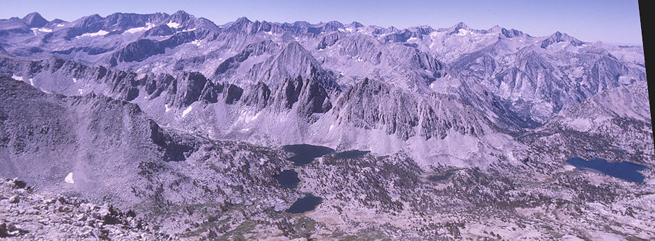
Upper Sixty Lakes Basin from Fin Dome
Kings Canyon National Park 31 Aug 1970

Sixty Lakes from Fin Dome
Kings Canyon National Park 31 Aug 1970

Sixty Lakes from Fin Dome
Kings Canyon National Park 31 Aug 1970

Mount Gardiner from Fin Dome
Kings Canyon National Park 31 Aug 1970

Mount Cotter, Mount Clarence King, Sixty Lakes Basin from Fin Dome
Kings Canyon National Park 31 Aug 1970
, unnamed, Mount Clarence King from Fin Dome<br>Kings Canyon National Park 31 Aug 1970")
Mount Cotter (left), unnamed, Mount Clarence King from Fin Dome
Kings Canyon National Park 31 Aug 1970

Mount Cotter and North Peak from Fin Dome
Kings Canyon National Park 31 Aug 1970

Mount Clarence King and Sixty Lakes Basin from Fin Dome
Kings Canyon National Park 31 Aug 1970

Mount Clarence King from Fin Dome
Kings Canyon National Park 31 Aug 1970

Sixty Lakes valley from Fin Dome
Kings Canyon National Park 31 Aug 1970

A Sixty Lake from Fin Dome
Kings Canyon National Park 31 Aug 1970

Lower Rae Lakes Basin from Fin Dome
Kings Canyon National Park 31 Aug 1970

Lower Rae Lakes Basin from Fin Dome
Kings Canyon National Park 31 Aug 1970

White Fork and lake near Ranger Station from Fin Dome
Kings Canyon National Park 31 Aug 1970

A lake near Rae Lakes Ranger Station from Fin Dome
Kings Canyon National Park 31 Aug 1970

A lake near Rae Lakes Ranger Station from Fin Dome
Kings Canyon National Park 31 Aug 1970

White Fork of Woods Creek from Fin Dome
Kings Canyon National Park 31 Aug 1970

Teen girl packer in Rae Lakes area
Kings Canyon National Park 31 Aug 1970
We camped in Sixty Lakes Basin and climbed Mount Cotter. Mount Clarence King was too difficult for me but I believe Gil Beilke and some of the others climbed it.
Mount Cotter, located in the Kings Canyon National Park, is named for Dick Cotter who was a packer with the California Geological Survey in 1864. Cotter and Clarence King made the first ascent of Mount Tyndall. The Mountain has an elevation of 12,719 feet.
The mountain is easily climbed from Gardiner Basin with a class 2-3 slope. There are more difficult routes found on the north and east sides of Mount Cotter. The mountain features a large class 4-5 summit block. Mount Cotter can be reached from the west or east side of the Sierra Nevada.

Mount Clarence King sunrise from Sixty Lakes Basin camp
Kings Canyon National Park 01 Sep 1970

Water stop on way to climb Mount Cotter
Kings Canyon National Park 01 Sep 1970

Flowers in Sixty Lakes Basin on way to Mount Cotter
Kings Canyon National Park 01 Sep 1970

Flowers in Sixty Lakes Basin on way to Mount Cotter
Kings Canyon National Park 01 Sep 1970

Flowers in Sixty Lakes Basin on way to Mount Cotter
Kings Canyon National Park 01 Sep 1970

Richard Alvernez, Roger Getz,Dale Caldwell, Gil Beilke on Mount Cotter summit
Kings Canyon National Park 01 Sep 1970

Roger Getz on top of Mount Cotter, Dale Caldwell, Richard Alvernez
Kings Canyon National Park 01 Sep 1970

On top of Mount Cotter
Kings Canyon National Park 01 Sep 1970

Looking south on Mount Cotter, Gil Beilke
Kings Canyon National Park 01 Sep 1970

Mount Gardiner and Gardiner Lake from Mount Cotter
Kings Canyon National Park 01 Sep 1970

Gardiner Lake Basin from Mount Cotter
Kings Canyon National Park 01 Sep 1970

Mount Clarence King from Mount Cotter
Kings Canyon National Park 01 Sep 1970

Ridge from Mount Cotter to Mount Clarence King
Kings Canyon National Park 01 Sep 1970

Ridge from Mount Cotter to Mount Clarence King
Kings Canyon National Park 01 Sep 1970

Mount Clarence King from Mount Cotter
Kings Canyon National Park 01 Sep 1970

Mount Brewer from Mount Cotter
Kings Canyon National Park 01 Sep 1970

White Fork Woods Creek, Mount Ickes from Mount Cotter
Kings Canyon National Park 01 Sep 1970

Sixty Lakes, Dragon Lake from Mount Cotter
Kings Canyon National Park 01 Sep 1970

Sixty Lakes Basin camp from Mount Cotter
Kings Canyon National Park 01 Sep 1970

Sixty Lakes Basin camp
Kings Canyon National Park 01 Sep 1970

Sixty Lakes Basin
Kings Canyon National Park 02 Sep 1970
We had a layover day in Sixty Lakes Basin during which some members of the group climbed Mount Clarence King.

Flowers in Sixty Lakes Basin
Kings Canyon National Park 02 Sep 1970

Frogs in Sixty Lakes Basin
Kings Canyon National Park 02 Sep 1970

Frogs in Sixty Lakes Basin
Kings Canyon National Park 02 Sep 1970

Stream in Sixty Lakes Basin
Kings Canyon National Park 02 Sep 1970

Stream in Sixty Lakes Basin
Kings Canyon National Park 02 Sep 1970

Moss in stream in Sixty Lakes Basin
Kings Canyon National Park 02 Sep 1970

Moss in stream in Sixty Lakes Basin
Kings Canyon National Park 02 Sep 1970

Moss in stream in Sixty Lakes Basin
Kings Canyon National Park 02 Sep 1970

Flowers in Sixty Lakes Basin
Kings Canyon National Park 02 Sep 1970

Moss in stream in Sixty Lakes Basin
Kings Canyon National Park 02 Sep 1970

Frog in stream in Sixty Lakes Basin
Kings Canyon National Park 02 Sep 1970

Fin Dome and forest fire smoke from Sixty Lakes Basin
Kings Canyon National Park 02 Sep 1970

Enroute to Gardiner Basin in Sixty Lakes Basin
Kings Canyon National Park 03 Sep 1970
We then moved over to the Gardiner Basin - some pretty country - Gardiner Peak out of my class. Trail stays on south bank near low point. Hard to follow in many places - lakes below Gardiner Pass are nice camping, etc. The trail over Gardiner Pass is no-longer maintained. Looks like easy traverse from just below Gardiner Pass to lake basin just out of Gardiner Basin.

Enroute to Gardiner Basin in Sixty Lakes Basin
Kings Canyon National Park 03 Sep 1970

Enroute to Gardiner Basin in Sixty Lakes Basin
Kings Canyon National Park 03 Sep 1970

Marmot enroute to Gardiner Basin in Sixty Lakes Basin
Kings Canyon National Park 03 Sep 1970

Marmot enroute to Gardiner Basin in Sixty Lakes Basin
Kings Canyon National Park 03 Sep 1970

Marmot enroute to Gardiner Basin in Sixty Lakes Basin
Kings Canyon National Park 03 Sep 1970

Marmot enroute to Gardiner Basin in Sixty Lakes Basin
Kings Canyon National Park 03 Sep 1970

Marmot enroute to Gardiner Basin in Sixty Lakes Basin
Kings Canyon National Park 03 Sep 1970

Marmot enroute to Gardiner Basin in Sixty Lakes Basin
Kings Canyon National Park 03 Sep 1970

Gardiner Lake Basin
Kings Canyon National Park 03 Sep 1970

Gardiner Lake Basin
Kings Canyon National Park 03 Sep 1970

Gardiner Lake Basin
Kings Canyon National Park 03 Sep 1970

Mount Gardiner and Gardiner Lake Basin
Kings Canyon National Park 03 Sep 1970

Gardiner Lake
Kings Canyon National Park 03 Sep 1970

Don Deck at Gardiner Lake
Kings Canyon National Park 03 Sep 1970

Gardiner Lake
Kings Canyon National Park 03 Sep 1970

Mount Cotter and Mount Clarence King from Gardiner Lake
Kings Canyon National Park 03 Sep 1970

Mount Clarence King from Gardiner Lake
Kings Canyon National Park 03 Sep 1970

Mount Cotter from Gardiner Lake
Kings Canyon National Park 03 Sep 1970

Gardiner Lake
Kings Canyon National Park 03 Sep 1970

Looking toward Gardiner Pass over Gardiner Lake
Kings Canyon National Park 03 Sep 1970

Lake on Gardiner Creek
Kings Canyon National Park 03 Sep 1970

Flowers along Gardiner Creek
Kings Canyon National Park 03 Sep 1970
We made camp at a lake on Gardiner Creek.

Looking toward Gardiner Pass from Gardiner Creek Lake
Kings Canyon National Park 04 Sep 1970

Lake at Gardiner Creek camp
Kings Canyon National Park 04 Sep 1970

Camp at lake on Gardiner Creek
Kings Canyon National Park 04 Sep 1970

Gardiner Creek
Kings Canyon National Park 04 Sep 1970

Gardiner Creek
Kings Canyon National Park 04 Sep 1970

Gardiner Creek
Kings Canyon National Park 04 Sep 1970

Gardiner Creek
Kings Canyon National Park 04 Sep 1970

Gardiner Creek waterfall
Kings Canyon National Park 04 Sep 1970

Mount Clarence King from Gardiner Creek
Kings Canyon National Park 04 Sep 1970

Gardiner Creek, Mount Clarence King, Gil Beilke
Kings Canyon National Park 04 Sep 1970

Trees and flowers along Gardiner Creek
Kings Canyon National Park 04 Sep 1970

Mount Clarence King and Mount Cotter from Gardiner Basin
Kings Canyon National Park 04 Sep 1970

Gardiner Creek
Kings Canyon National Park 04 Sep 1970

Gardiner Creek waterfall
Kings Canyon National Park 04 Sep 1970

Fractured rock along Gardiner Creek
Kings Canyon National Park 04 Sep 1970

Plant on Gardiner Creek
Kings Canyon National Park 04 Sep 1970

Lake near Gardiner Pass
Kings Canyon National Park 04 Sep 1970

Water fall on Gardiner Creek
Kings Canyon National Park 04 Sep 1970

Gardiner Creek
Kings Canyon National Park 04 Sep 1970>

Tree at Lake near Gardiner Pass
Kings Canyon National Park 04 Sep 1970

Lake near Gardiner Pass
Kings Canyon National Park 04 Sep 1970

Tree at Lake near Gardiner Pass
Kings Canyon National Park 04 Sep 1970

Gil Beilke checking out the little tree on Gardiner Creek
Kings Canyon National Park 04 Sep 1970

Grassy lake near Gardiner Pass
Kings Canyon National Park 04 Sep 1970

Grassy lake near Gardiner Pass
Kings Canyon National Park 04 Sep 1970
We made camp at a lake below Gardiner Pass and then crossed it the next day. I think Gil Beilke and others climbed Mount Gardiner.

Lake near Gardiner Pass
Kings Canyon National Park 05 Sep 1970

Lake near Gardiner Pass
Kings Canyon National Park 05 Sep 1970

Gardiner Pass
Kings Canyon National Park 05 Sep 1970

Lake near Gardiner Pass
Kings Canyon National Park 05 Sep 1970

Lake near Gardiner Pass
Kings Canyon National Park 05 Sep 1970

View near Gardiner Pass, notice the single spire
Kings Canyon National Park 05 Sep 1970

Looking back on Gardiner Basin from Gardiner Pass
Kings Canyon National Park 05 Sep 1970

Lake we camped at from Gardiner Pass
Kings Canyon National Park 05 Sep 1970

Toward Charlotte Lake from Gardiner Pass
Kings Canyon National Park 05 Sep 1970

Charlotte Lake and University Peak from Gardiner Pass
Kings Canyon National Park 05 Sep 1970

Charlotte Lake and University Peak from Gardiner Pass
Kings Canyon National Park 05 Sep 1970

Gil Beilke on Gardiner Pass
Kings Canyon National Park 05 Sep 1970

View from Gardiner Pass
Kings Canyon National Park 05 Sep 1970

Mount Ericsson from Gardiner Pass
Kings Canyon National Park 05 Sep 1970

Mount Ericsson from Gardiner Pass
Kings Canyon National Park 05 Sep 1970

On Gardiner Pass
Kings Canyon National Park 05 Sep 1970

Mount Brewer and North Guard from Gardiner Pass - Kings Canyon National Park 05 Sep 1970

Mount Brewer from Gardiner Pass
Kings Canyon National Park 05 Sep 1970

Charlotte Dome from trail descending from Gardiner Pass
Kings Canyon National Park 05 Sep 1970

Charlotte Dome from trail descending from Gardiner Pass

Warning sign at bottom of Gardiner Pass Trail
Kings Canyon National Park 05 Sep 1970
The "trail" from Gardiner Basin over Gardiner pass and down to Charlotte Lake had been abandoned and isn't maintained (as the sign says). On this 1970 trip we had no trouble following portions of the old trail coming down and making our own way cross-country when necessary.

Charlotte Lake
Kings Canyon National Park 06 Sep 1970

Kearsarge Pinnacles and Lakes
Kings Canyon National Park 06 Sep 1970

Kearsarge Pass, Kearsarge Lakes
Kings Canyon National Park 06 Sep 1970

Signing the register on Kearsarge Pass
Kings Canyon National Park 06 Sep 1970

The RED line is the approximate backpacking route. The BLUE line is the approximate climbing route to Fin Dome and Mount Cotter. Mt. Gould is just a short distance off the backpacking route.
This was a great trip. This report of a similar 2013 trip, but in the opposite direction, covers much of our route and has lots of pictures. This report of a 2017 trip, also in the opposite direction, provides good comment on the route.