Mineral King is a subalpine glacial valley located in the southern part of Sequoia National Park, in the U.S. state of California. The valley lies at the headwaters of the East Fork of the Kaweah River, which rises at the eastern part of the valley and flows northwest. Accessed by a long and narrow winding road, the valley is mostly popular with backpackers and hikers.
Historically, the valley was inhabited by the Yokuts tribe during the summer months. They would come up to escape the high heat of the Central Valley and to hunt and forage. They would also meet with bands coming over from the eastern side of the Sierra to trade. In the 1870s, silver was discovered on the slopes of a mountain overlooking Mineral King. Mineral King Road was built in 1873 and was gradually improved throughout the early 20th century.
On September 19, 1966, Walt Disney Productions announced plans to build a ski resort called "Disney's Mineral King Ski Resort" in the valley. The project was canceled after lengthy opposition by preservationists, including the Sierra Club. In 1978, the valley became part of Sequoia National Park.
The name Mineral King also refers to the historic mining camps and towns in and near the valley, including Silver City and Cabin Cove. The settlements as a whole are referred to as the Mineral King Road Cultural Landscape, which was added to the National Register of Historic Places in 2003.
I backpacked several times in the Mineral King area.
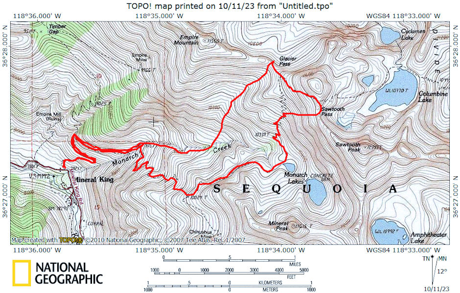
The first was by myself on May 13-15, 1972 on a ten mile round trip. I drove to Mineral King from San Diego. Noted limited parking. Good road - steep in places, 75% or more paved, rest smooth decomposed granite. There was one seasonal gas pump at Silver City. Seven day camping and parking limit.
I hiked up the trail to Monarch Lakes - rebuilt from old junction with Timber Gap Trail almost all the way to "Lower Ground Hog Meadow" - beautiful falls on Monarch Creek (Ran into Wes & Willie Reynolds, Dave Kemp, Dave Paul)
Took old trail to Monarch Lake (per map) however there is a new trail taking off from Crystal Lake Trail and going up opposite side of creek - camped at lower Monarch Lake.
Next day went cross-country and trail to Sawtooth Pass (11,600) - view of Columbine Lake (frozen), Mt. Whitney, Kaweah's. Then to Glacier Pass via ridge (old trail), then down old Glacier Pass trail to camp at Lower Groundhog Meadows. Snow on north side of both passes but passable with ice axe (maybe without). Either should be okay trail later in summer.

Mineral King Route Map 1972
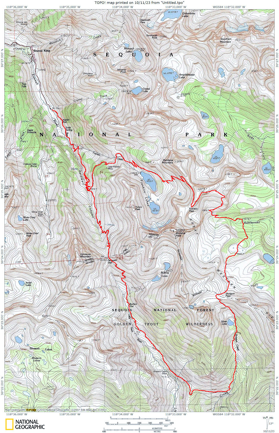
The second trip was a 22 mile round trip backpack on August 12-15, 1978 with Rody Troeter, Tim Miller and Leon Warner.
We drove from Lone Pine to Mineral King Friday night - left at 5 p.m. and made road end at 12:30 a.m. Sacked out in the car.
On Saturday I took food for a later vacation trip to Mineral King Packer and got permit for this trip, then hit the trail about 8 a.m. Good trail - beautiful flowers - to Franklin Lakes. Had lunch about a mile below lower lake. Made camp at hidden campsite above main trail opposite spring which is below the trail opposite the dam. Made camp about 2:30. Cool and breezy. Took pictures between clouds, napped, had supper, hit the sack early.
Up Sunday at 7 a.m. and on the trail before 9. Good trail to Franklin Pass - arrived about 11:30 and ate lunch on pass. Morning weather had been cloudy but it all blew away about noon. Great views. Descended to Rattlesnake Creek for second lunch about 12:30. Hit the "trail" about 1:20 going cross country until we picked up ducks which we followed to the old Shotgun Pass trail across easy slopes.
The well ducked trail is easy to follow. Crosses nice meadow then climbs to the Pass over easy slabs and meadows. Made the pass around 3 p.m. or so. Great views. Enjoyed the pass for half hour or so, then descended sandy slope to Silver Lake. Nice campsite at inlet end. (Poorer sites at outlet). We saw no people after we left Rattlesnake Creek. It appeared only a horseman had been on the trail before us. Enjoyed the camp and hit the sack early again.
Monday we were up at 7 a.m. and on the trail by 8:30. Trail is not maintained and rocky in places. Descends steeply to a meadow area, then easier sandy trail before finally dropping steeply to the Farewell Gap trail. (Trail does not cross creek as shown on topo.) Sign at trail junction says Mineral King 14 miles - not so - more like 10.
Easy trail takes you into the headwaters of the Little Kern below Farewell Gap. Trail does not pass Broder Cabin - junction is 1/4 to 1/2 mile above cabin. We had snacks at several side creeks as we proceeded toward Farewell Gap. Met first people in two days - packer and three boys. Ate lunch at the creek crossing from Bullfrog Lakes. (We could have gone up to these lakes to camp but would have been later leaving for home Tuesday). Continued over Farewell Gap after lunch and made camp on small bench with trees about two miles or less below pass. Marmots all over the place on this trip.
Hit the sack early again and up Tuesday at 7 a.m. On the trail about 8:30. Easy downhill put us at the car about 10:15. We made Visalia about 12:30 for lunch, then returned via Porterville and Lake Isabella arriving in Lone Pine just after 6 p.m. Great trip - wild flowers out of this world. Estimate - Franklin Lakes 6 miles, Silver Lake 6 miles, Camp below Farewell Gap 6 miles, Mineral King 4 miles.

Mineral King Route Map 1978
