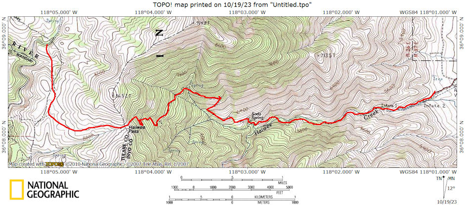
The Haiwee Pass trail is located in the eastern portion of the South Sierra Wildeerness. The trail begins at 4,940 feet near Haiwee Creek, and climbs to Haiwee Pass, at 8,500 feet.
The trail is primitive and can be overgrown or faint in places as it winds through canyon live oak woodland, crossing Haiwee Creek several times. At Haiwee Pass, one can continue westward towards the South Fork of the Kern River, or head north towards Olancha Pass and Summit Meadows.
On April 7-8m 1973 Steve Vicklun and I did a 12 mile round trip backpack over 8200' Haiwee Pass.
We drove 272 miles from San Diego to the end of Haiwee Canyon road. The road leaves highway 395 fifteen miles north of Little Lake. Well graded gravel to old Sam Lewis Pack Station. Sign here says Haiwee Pass 6 miles, Kern River 8 miles, Monache Meadow 20 miles.
Narrower road continues about half mile to beginning of trail. Room to turn around and park several vehicles. Monache Mtn (15 Minute) topo map does not show trail properly. After the fork in the creek, there are switchbacks. Trail is well graded. It follows the creek to fork (appears possibly year round water) then turns north and starts up side of ridge.
Shortly after starting this climb, a small spring right next to the trail is the last water. This spring probably dries up during summer. The hike is pleasant and the views nice. Would be hot in late summer.
| Location | Elevation (feet) | Distance (miles) | Accumulated Distance (miles) | Grade | Elevation Change |
|---|---|---|---|---|---|
| Roadhead, Haiwee Creek | 4900 | 0.0 | 0.0 | 0.0 | 0.0 |
| Fork in Creek (stay north) | 5800 | 2.0 | 2.0 | +450 | +900 |
| Haiwee Pass | 8200 | 4.0 | 6.0 | +600 | +2400 |
Most of the trail is on a south facing slope so the snow melts early. We didn't run into significant snow on the trail until about 7800 feet. We avoided this by going directly up a gully on steep but class 2 terrain. All of the terrain in this area is relatively easy with a few rocky places.
It would not be technically difficult to climb Round Mountain from the pass: Round Mountain 9884' 4.5 miles +574 +1684 You can follow near the crest but still must do some up and down. It is probably just as fast to follow a fairly straight route.
I explored the route for about a mile but didn't go all the way because of time and snow conditions. We camped on a little knoll at about 8400 feet with a view of Round Mtn, and Olancha Peak out the front door. It would not be far to come over the pass and down to the Kern River. May might be a good time to do this hike. The Kern River could be quite high and difficult (or impossible) to cross during high runoff period.
We had a clear night at the roadhead but low clouds enveloped the entire valley about 7 a.m. and obscured the peaks and view until after noon. This also made the climb nice and cool. There were high clouds in the afternoon which started to clear around dusk and were gone in the morning.
Sunday was clear and sunny. Windy at times but nothing steady - and, it was relatively warm. We snowshoed and slide down the snow from the pass to where we had left the trail on Saturday. About 2 1/2 hours down.

Haiwee Pass/Kern River 1973-1978
On June 11, 1978 Randy Stevenson and I did a 16 mile round trip hike over 8200' Haiwee Pass to the South Fork of the Kern River.
I picked Randy up in Independence about 7 a.m. and drove to Haiwee Canyon roadhead. Hit the trail about 8 a.m. Very pleasant weather with minimum of bugs. The creek was running down the trail in a few spots causing some wading but nothing major. Water had been higher but never high enough to be a major problem. Many flowers along the route.
We got water at the fork in the creek - from the north fork - should have gotten from below the junction to dilute the "iron" taste in the north fork water. Also further up the north fork probably is better tasting water although it wasn't all that bad.
We stopped again for better water at a spring well up the hill. We made the pass (6 miles, 3,300' climb) just before noon in four hours of steady but not rushed climbing. Would be longer with full pack.
After lunch we hiked the 2 miles down to the South Fork of the Kern dropping 800 feet. Found small spring about half way where we got water on the way back. The S.F. Kern was running very heavy but was below its peak. It was very dirty also.
We headed back to the pass about 1:30 and made it about 2:30. After a breather we headed down for the car arriving shortly after 4 p.m. (I think). There was no snow on the trail or nearby. A couple of small patches on nearby ridges. We could see some snow over on the great western divide and Kern Peak and Olancha Peak. Great day and trip.
