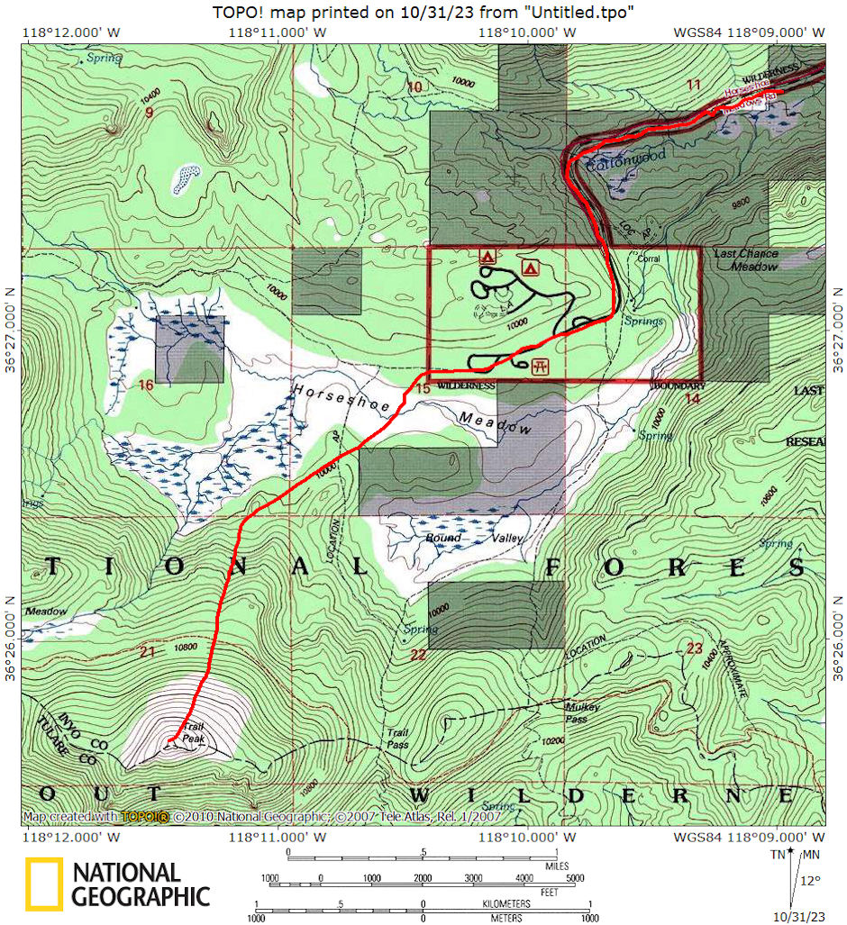
On May 3, 1975 I did a 7 mile round trip day hike to 11,723' Trail Peak in the Golden Trout Wilderness.
A few miles south of the granite giants at the end of the eastern High Sierra is the Kern Plateau. This is a land of high sandy meadows and forested walk-up peaks. The area is less dramatic than the peaks and canyons to the north but has its own beauty and solitude.
Trail Peak is the 3rd highest peak on the Kern Plateau (Olancha Peak the highest) and has commanding views across the Golden Trout Wilderness and as far south as Owens Peak. To the west the southern part of the Great Western Divide peaks grace the horizon. To the northwest loom the Kaweah Peaks. To the north Cirque Peak and Mt. Langley round out the southern end of the eastern High Sierra and to the east over Owens Valley, the Inyo Mtns. and desert ranges stretch back to Death Valley.
I left Lone Pine about 8:15 am and drove Horseshoe Meadows road until stopped by snow. The road department had cleared the road to within about a mile of the end where there was still several feet of snow. The snow was firm so I carried my snowshoes and headed up the road about 9:20 am.
A couple was just ahead of me but turned off the road shortly and I had the area to myself all day. I crossed Horseshoe Meadow and Round Valley and headed more or less directly for the peak.
I put on snowshoes at the edge of Round Valley where the trees made the snow firmness unpredictable. The climb was steep but relatively easy on the smooth snow with good traction due to the surface melt.
It was fairly windy so I stayed in the trees up to the ridge, then followed the lee side of the ridge to the summit - arriving at 1:30 pm. Found a Forest Service radio repeater station on top and good views of the whole south end of the Sierra.
Ate lunch out of the wind behind summit rocks and took pictures. There was still a fairly complete snow cover everywhere in the back country but ground was beginning to show in spots in some of the interior meadows.
A storm was moving in on the East but strong winds from the west seemed to be keeping it away from the main Sierra on the south end. The clouds were building up to the north toward Whitney and the Kaweah range.
I left the summit about 2:20 pm. and after returning to the trees headed straight down the fairly steep slope and back across Horseshoe Meadows. On the way up and back I followed tracks of a loan skier and probably a snowshoer (could have been the same person, probably two parties) from earlier in the week or the previous weekend. On the way back, just before reaching the trees at the east side of Horseshoe Meadow I saw a coyote. Arrived back at the car about 4:20 p.m. and took a leisurely drive home.

Trail Peak day hike map 1975
