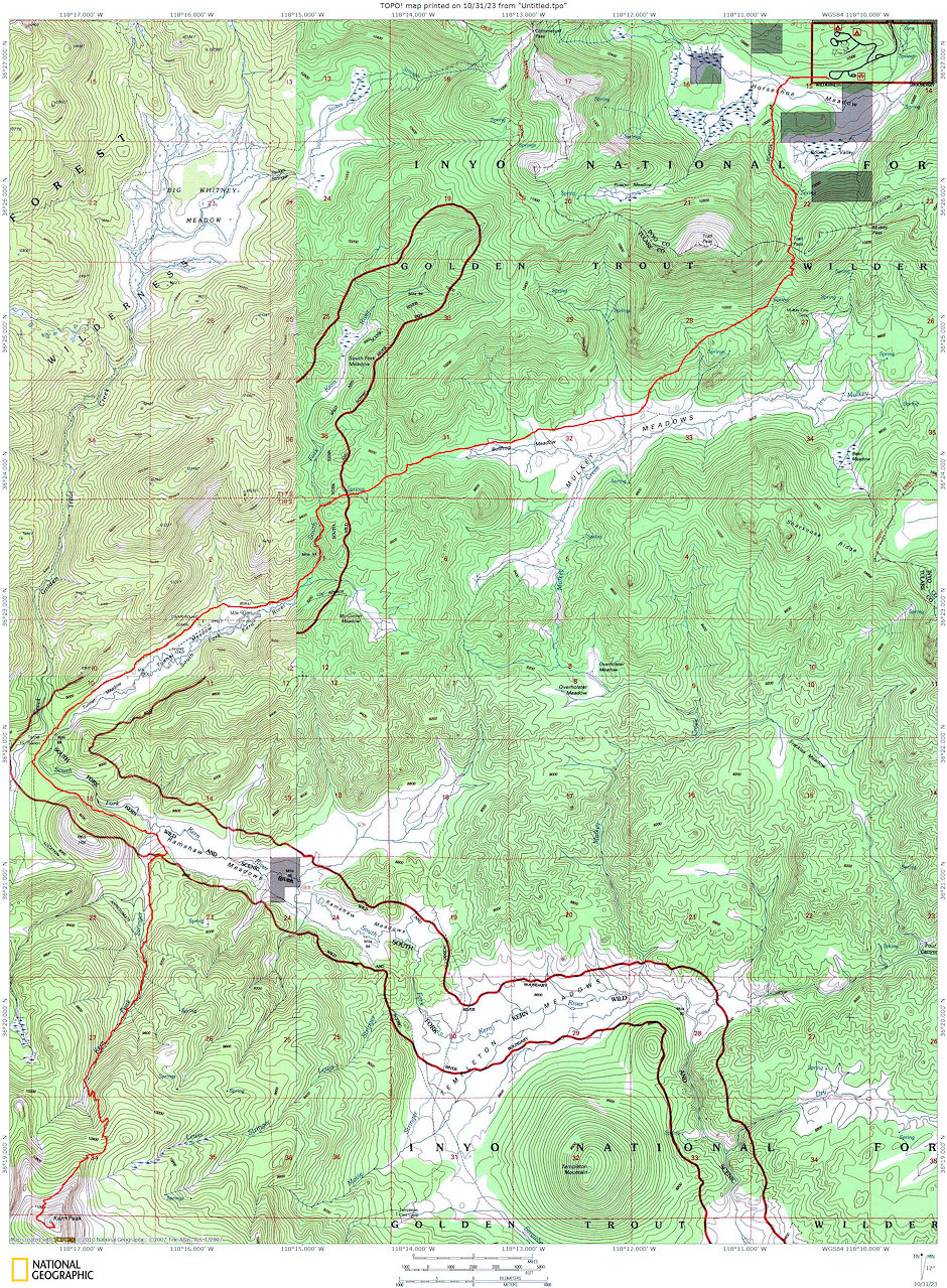
On May 24-26, 1975 myself, Gordon Lee and John Lee went on a 31 mile round trip backpack to 11,510' Kern Peak.
Kern Peak is located in a very remote area of the southern Sierra in the eastern section of the Golden Trout Wilderness. At 11,510 feet, it is not actually a high Sierra peak. Kern Peak lacks the alpine qualities of the Sierra Crest found a few miles north at Chicken Spring and Rocky Basin Lakes, and Olancha Peak to the east, which anchors the southeastern end of the High Sierra.
Instead, Kern Peak is set on the broad, 8-10,000 feet Kern Plateau, which contains several large meadows, rolling hills, and vast upper montane forests consisting of foxtail and lodgepole pines. Although it is remote, the rolling, sandy landscape is easy to traverse.
Along with Olancha and Cirque Peaks, Kern Peak is probably the most prominent point in the eastern section of Golden Trout Wilderness. It thus has sweeping views of the middle and upper Kern River drainage and much of the far southern Sierra, including Olancha Peak, the Langley and Whitney areas, the southern Kaweah Range, the mountains of the Mineral King area and the western section of the Golden Trout Wilderness, and the Dome Land Wilderness of the far southern Sierra.
Because it overlooks such a large area, Kern Peak was formerly a fire lookout. Remnants of the lookout, including much debris, remain on the summit. Kern Peak is most commonly climbed using the class 1 trail to the top. Much of the area immediately south of Kern Peak was burned in the summer of 2002 by the 150,000 acre McNally fire.
We gathered at my apartment in Lone Pine Friday night - Gordon from San Diego and John from Mammoth. Saturday morning we drove to the end of the Horseshoe Meadows road and hit the trail about 8:15 am. The trail to the top of Trail Pass was covered with snow but it was still firm in the morning so we made good time to the pass, arriving about 10:00.
After a rest stop we proceeded down the now snow free trail to Mulkey Meadow where we ate lunch and had a long rest. We then proceeded northerly past Bullfrog Meadow to the low pass leading to the headwaters of the South Fork of the Kern River. We dropped down and followed the river to Tunnel Meadow.
On the long hike past the meadow we saw the Tunnel Air Camp and found some people had flown in for the weekend. We finally reached the Tunnel Guard Station, after passing the blocked off ditch which at one time was used to feed Golden Trout Creek into the Kern. We made camp on the South Fork of the Kern and after supper hit the sack early. About 10 p.m. we awoke to watch a total eclipse of the moon.
Sunday we were up at 6 and after breakfast hit the trai1 about 8 am for Kern Peak. We followed the trail to Ramshaw Meadow and then up the indistinct trail along Kern Peak Stringer. The going was not difficult and we stopped for lunch at about 10,000 feet just as we ran into heavy snow.
At 1:00 we started up the mostly firm snow to the northeast ridge and on up the rocks to the Peak, arriving about 2:30. The views to the north, east and west were outstanding. About 3:15 we headed down and reached camp about 6:30. After supper we hit the sack early.
Monday morning it was almost 9 before we got out of camp. The hike was pleasant. The pull from Mulkey Meadow to Trail Pass was tiring. Left the pass about 3 and slopped down through the snow to Horseshoe Meadows and reached the car about 4:30. Drove down to my apartment for showers and farewells as John and Gordon headed south after a tiring but pleasant weekend.

Route map to Kern Peak 1975
