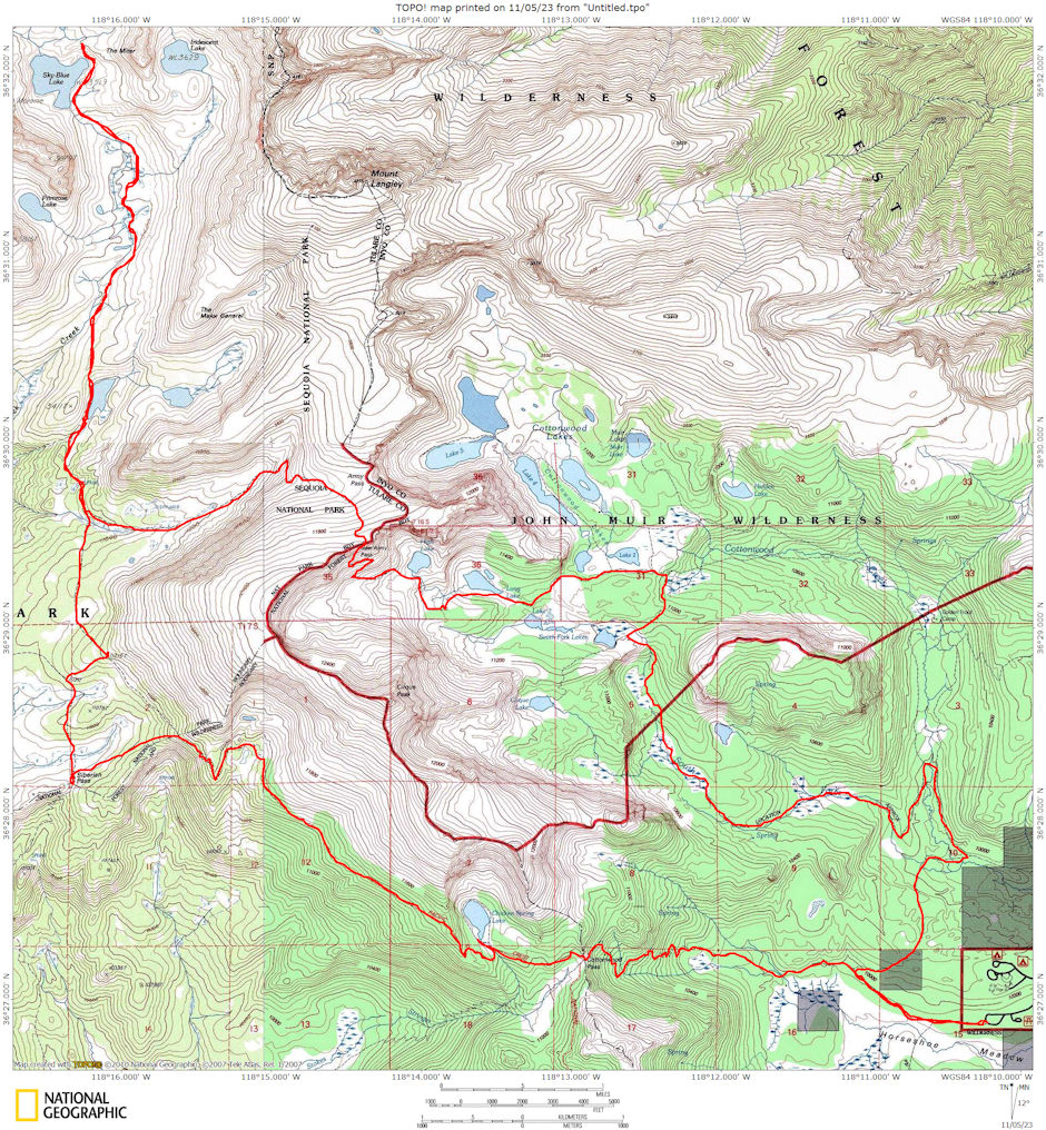
On June 27-29, 1975 I took a 28 mile round trip backpack into the southern Rock Creek area in the Golden Trout Wilderness/John Muir Wilderness and Sequoia National Park.
I left the Horseshoe Meadows roadhead at 7 p.m. Friday evening and hiked to Chicken Spring Lake. The four miles to Cottonwood Pass took two hours and I arrived just as it got completely dark. A half hour later I made camp at Chicken Spring Lake which I reached via the new Pacific Crest Trail section.
Got up about 7 a.m. and found a couple camped across the lake. After breakfast I hit the trail about 8 a.m. on the new Pacific Crest Trail to Siberian Pass. This section offers some outstanding views of the Big Whitney Meadows, Kern and Olancha Peaks.
Water a little over half way to Siberian Pass where the trail goes between two small lakes. The upper lake is out of view and the lower lake is full of grass - almost a meadow, but there is good water and suitable areas to camp.
Arrived at Siberian Pass after a leisurely hike at 11:30. Ate lunch and took a Siesta until 12:30. Then headed for Rock Creek. The trail crosses two low ridges separating meadows. There is water near Siberian Pass, at the next meadow north, and along the Army Pass Trail.
At the Army Pass trail junction I met Paul Durantine who was on a three week solo backpack. We joined up for the rest of the day and camped together at "Upper Rock Creek Lake".
We took a day hike about two miles up Rock Creek into the lower Miter Basin. A fairly good trail exists much of the way. Met a Sierra Club group coming in from Army Pass for a week of climbing (7 people). Made it back to camp for talk after supper.
Sunday Paul prepared to go to Crabtree Lakes while I headed for New Army Pass. The trail follows a creek much of the way and there are lots of marmots. Made the Pass at 1:00 after starting about 9:30. Ate lunch and took a Siesta until 2 p.m. Met party of 4 headed for Kern River via Rock Creek and several parties going or coming from Mt. Langley.
The pass was still partly blocked by fairly steep snow (even some cornices) but I traversed it with no trouble and hit the trail past High, Long and Cottonwood Lakes 1 & 2. I took the side trail to Lower South Fork Lake (and Cirque Lake), then a use trail down the South Fork through a number of meadows and fine camp areas. I eventually reached the main Cottonwood Trail and shortly thereafter arrived at the road - about a mile below my car. Hiked up the road to the car and drove home. Made the car about 6:30. This was a long hike but a great weekend. Saw lots of new country.

Route map for 1975 Rock Creek South trip
