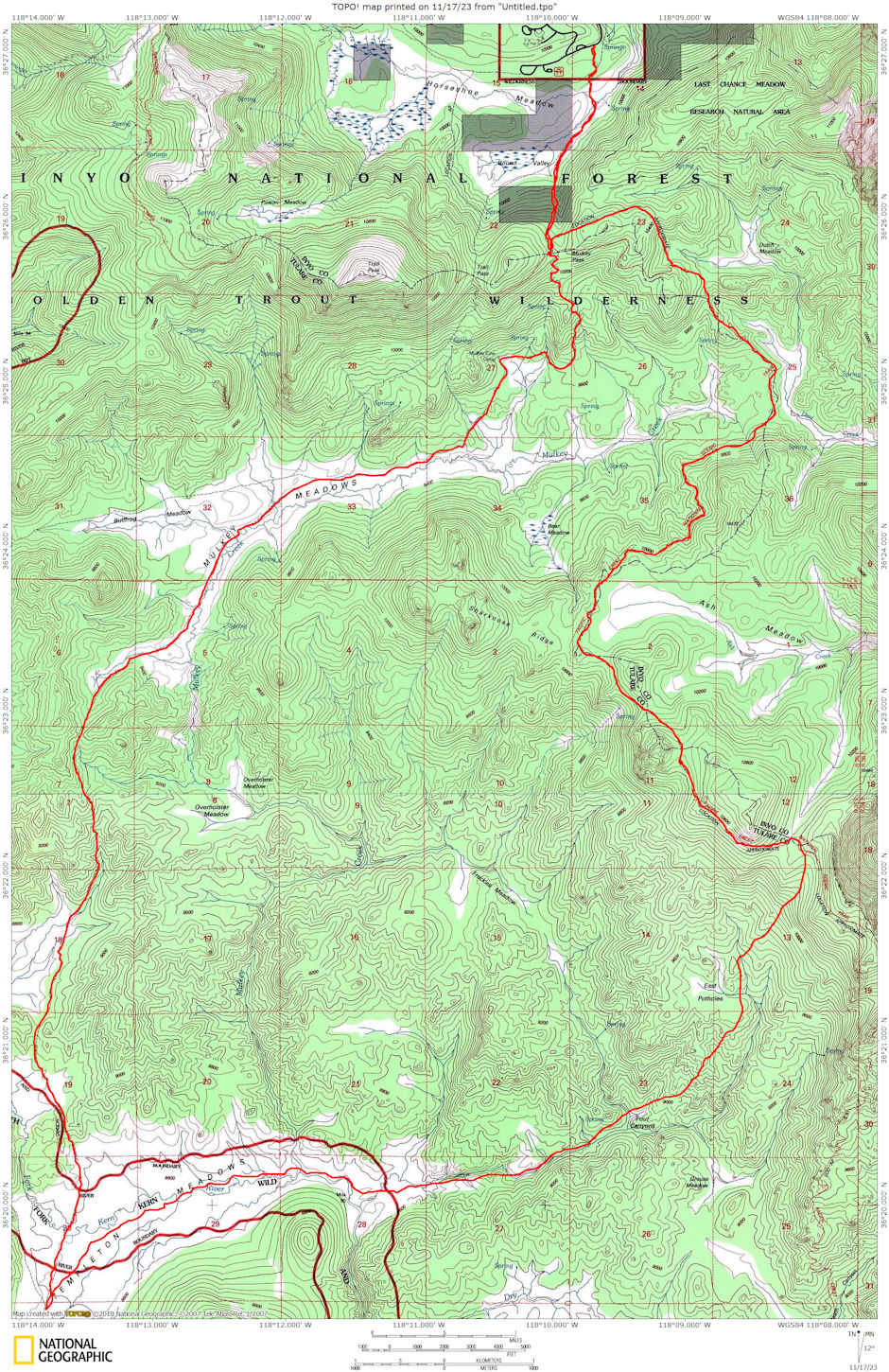
On May 22-23, 1976 I took a 30 mile round trip backpack to the Templeton Meadow area. I got up early Saturday and drove to end of road at Horseshoe Meadows. Hit the trail about 7:30 a.m. while most of the southlanders were still sleeping.
Went to Mulkey Pass, then on the new Pacific Crest Trail to the south. The trail stays near the crest and you always have Trail Peak and Langley in view until you get south of Sharktooth Ridge, then Olancha Peak takes over - also Kern Peak.
The trail is almost devoid of water since it follows the crest. A sign indicating "Corral" led me to a corral and former trail crew camp at Dutch Flat Meadow where I found water.
The trail crosses the saddle at the east end of the Mulkey Meadow valley at the foot of Muah Mountain. You could go west to water and camp at the head of Mulkey Meadow. The trail then climbs steadily - easily - to the top of Sharktooth Ridge, then along the top of the ridge just within sight of glimpses of Ash Meadow.
After finally crossing over the ridge, and climbing slightly, you come to another "Corral" sign which goes to a former trail crew camp on a branch of Ash Meadows. The water here was almost dried up. If I had gone further down the stream, I probably would have found running water. I had eaten lunch just before arriving at this sign, so filled my water bottle with snow as a reserve against finding water later.
Shortly I came to a saddle on a southerly branch of Ash Meadows. I had met two Forest Service trail crewmen on the trail earlier, and they took a short cut from where the trail first almost tops Sharktooth Ridge, across Ash Meadows, to this saddle. A use trail makes it easy to spot.
At this point I decided to drop down the west slope and make my way to Templeton Meadow. I soon hit a stream where I could refill on water. I cut across some low ridges and eventually started down cattle trails paralleling a stream.
I stayed on the trails and bypassed the Four Canyons area before getting down into the stream bed. Lots of water and very pretty. I finally broke out into the open spaces of Templeton Meadow. Checking my map, using Templeton Mountain, I made sure of my location and directions, then headed across the large meadow for the Ramshaw Meadow and Mulkey Meadow trail junction.
I quickly came along side the South Fork of the Kern River, following it upstream. It was running low, about like you would expect in late summer. About 6 p.m. I finally made camp near the river as it enters Templeton Meadow from Ramshaw Meadows. The 17 mile day made the long nights sleep quite welcome as I hit the sack about 8 pm. Two airplanes were at the Meadow and took off about dusk - leaving the area after buzzing around a while.
In the morning I had frost on the tent and a skim of ice on the water bucket and in the water bottle. The sun warmed things quickly and I finally got out of bed about 7 a.m. Fixed breakfast, took a cold but refreshing quick dip in the river to wash away the trail dirt, and hit the trail about 8 a.m.
I hiked south on the Ramshaw Meadow trail to the actual trail junction for Mulkey Meadow, then up the Mulkey Meadow trail. Kern Peak was ever visible as the route crossed the easterly ends of Ramshaw Meadow branches before heading up a valley in which a spring fed trickle ran. I refilled on water just before the final steep climb to the ridge that led to Mulkey Meadow.
I stopped for lunch at the top and took a rest in the sun. I then headed down to Mulkey Meadow about 1 p.m. and continued up Mulkey Creek to the junction with the Tunnel Meadow and Trail Peak trails. Here I decided to continue to the Mulkey Pass trail. I stopped briefly at the Mulkey Cow Camp - found Cris Carrasco's name from a 1945 deer hunt penciled on the cabin. This cabin would make a good ski tour stop, provided it is not left open and allowed to fill with snow.
Finally made it over the pass and to the car about 5 p.m. after a 13 mile day - 30 miles in all. A little long, but I enjoyed the trip.

Route map for Templeton Meadow 1976
