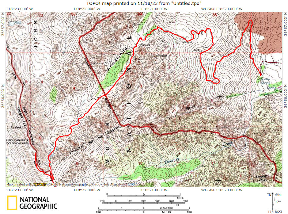
On June 12-13, 1976 Marty Nicolaus and I took an 8 mile round trip backpack over a 12,000'+ ridge via Armstrong Canyon.
I picked up Marty in Independence about 6:30 a.m. and we drove to the old mine road above the Division Creek Powerhouse. The road is passable to ordinary vehicles as far as Scotty's Spring. Beyond this 4 Wheel Drive is advisable. The road is really in good shape except for a few drifted in spots and rocks. We drove my International to within a 1/2 mile of the end - could have gone all the way it turned out.
We started hiking about 8 a.m. at about 8100 feet on the road. From the end of the road you follow a steep gully on large rocks which provided good footing. Around 9000 feet the terrain levels out quite a bit. You find easy going over sand and gravel with grass most of the time until you reach the base of a moraine.
At this point, after climbing to the top, we stayed to the left on snow most of the way and avoided very much hard rock hopping until reaching a sort of flat rocky area at about 11,000. At this point is the wreck of an early jet fighter. We had stopped for about a hour at 10 a.m. and stopped at the plane wreck about noon or 12:30. We toured the wreck and ate lunch, leaving about 2 p.m.
We had a 1000 foot fairly steep snow climb to the ridge. I had not brought an ice axe so had picked up a stout stick along the way - this served fine since the snow was melted enough to provide good footsteps. It took two hours of fairly steady going to reach the ridge - about 4 p.m. We decided to camp on the sandy level saddle just to the south - at the head of Division Creek. We used Marty's new North Face Tent. There was a light breeze and the sky was slightly cloudy - temperature about 40. We set up camp and fixed supper - drifting off to sleep about 8 p.m. The wind quit for a while, then in the early morning came up strong and a lot of frost formed on the ground as clouds covered the area.
We were lazy in the morning but finally got up about 8:30 when the wind stopped. After breakfast and packing we finally headed for Mt. Perkins about 11 a.m. An hour later we decided the going was too slow - rocky ribs - loose rock - would have taken two hours to reach the peak (if no major problems popped up) and two hours to get back - this would take too long and neither of us cared for the steep loose rock - so we stopped on top of a high point along the ridge and enjoyed the outstanding views and what had turned into outstanding weather.
Sometime after 1 p.m. we decided to head down, returned to camp and about 2 p.m. returned to the head of the snow chute we had ascended on Saturday. The chute was about 60 degrees and the snow was just right for a controlled glissade - even with my substitute "alpenstock". We glissaded down in about 15 minutes and headed on down the canyon, reaching the car in fine shape about 4:30 p.m. It was really a great trip.
P.S. This is not the best approach to climb Perkins unless you have three days. You can then drop down from our ridge to the Twin Lake basin, proceed to the base of Perkins on its west slope, and climb it from there.

Armstrong Canyon/Mt. Perkins Ridge route map
