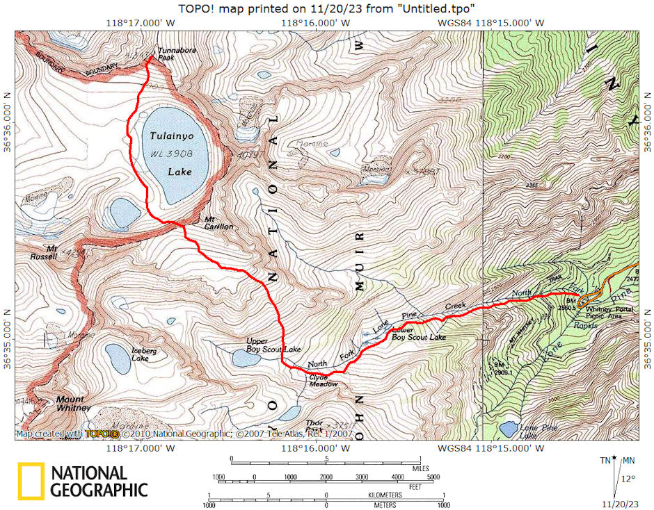
On August 7-8, 1976 I took a 13 mile round trip backpack to climb 13,565' Tunnabora Peak with Marty Nikolaus, Frankie Nikolaus, Randy Stevenson, Al Nikolaus and Bill Caipen.
Tunnabora Peak is located along the Sierra Crest, west of Lone Pine,California. At 13,565 feet, the peak is overshadowed by its higher neighbors to the south, Mounts Russell, Whitney, and Muir. Tunnabora's relatively diminutive stature in comparison to these 14ers, in combination with what could charitably be described as less than classic climbing (some trip reports have given it the rather pejorative appellation of Tunnaboring), means the peak is infrequently climbed.
But those few who do make it up here are treated to excellent views that compensate for the poor climbing. To the south, one looks over unusual Tulainyo Lake, one of the highest lakes in the continental United States, to Mt. Russell's impressive North Ridge. To the north lies the immense Mount Williamson and Vacation Pass.
Tunnabora is perhaps best climbed in combination with some of the aforementioned peaks. A loop of Carillon, Tunnabora, Russell, Whitney, and Muir can be done out of Whitney Portal as a reasonable day hike--the scenery is grand, the scrambling excellent on Russell, Whitney, and Muir, and the loop knocks off five SPS peaks in one day. Fun!
The usual route up Tunnabora Peak is a fairly tedious slog up its sandy south slopes from Tulainyo Lake (class 1). Keeping to the left may offer marginally more solid footing, but don't expect a great climb whichever way you go. Another option is offered by a chute on the northwest face, which is class 2 from George Creek.
We left my place in Lone Pine about 6:30 a.m. and hit the trail at Whitney Portal about 7:30 a.m. We made good time up the well-worn route and made camp above Clyde Meadow on a nice sandy bench at about 1 p.m. after talking with some Scouts and others along the way.
Marty, Randy and I decided to go ahead and climb Tunnabora, and Al to go to the Russell Carillon saddle to see the route up Russell. After about an hour, Randy decided to return to camp and rest up for Russell the next day. At the saddle, Al decided to climb the remaining short distance to the top of Carillon while Marty and I continued on to Tunnabora.
Al did Carillon and returned to camp. Marty and I left the ridge at about 4 p.m. and dropped the 500 feet to Tulainyo Lake, highest in North America, then on to Tunnabora - arriving on the peak about 6:00 p.m.
I had an upset stomach which slowed me down some and I didn't feel too great on the peak. After some food and rest I felt better. We enjoyed some nice views. About 7 p.m. we headed back, taking about an hour to reach the bottom of the 500 foot climb, and half an hour to climb to the ridge - arriving at 8:30 as it turned dark. On the way across we had great alpine glow and a full moon over Mt. Carillon.
With the full moon the descent to camp was no problem and we arrived in 45 minutes at 9:15 p.m. We fixed supper and hit the sack.
On Sunday morning Al got the group up at day break - I slept in and rested up from my stomach problem all day. After breakfast, they hit the hill about 7 a.m. for Mt. Russell. Al, Frankie and Randy made Russell while Marty and Bill did Carillon, all returning to camp about 3:30/4 p.m.
Russell route was Class 3 but presented some pretty severe exposure in several spots. One spot over the top of a large block apparently is the decision point going up. We left camp about 4:30 and made the cars around 6 p.m. The weather was great and the scenery outstanding.

Tunnabora Peak route map 1976
