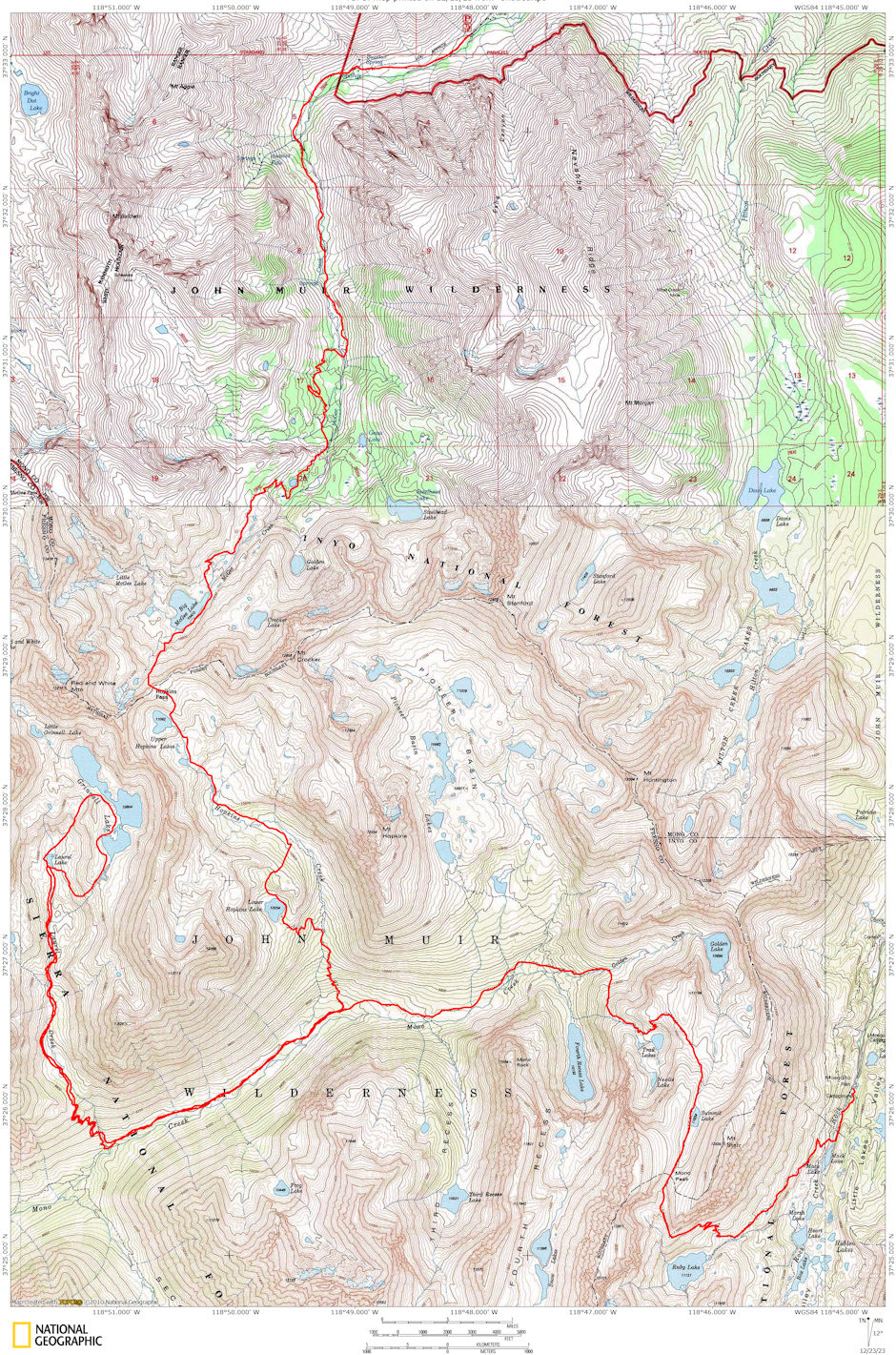
On July 4-8, 1979 myself, Gordeon Lee, Stan Haye and Jim White took a 37 mile backpack including a two mile day hike in the John Muir Wilderness in the Grinnell Lake Basin.
Stan spotted his car at the McGee Creek roadhead Tuesday night. Wednesday morning Gordon and I picked up Jim in Independence, Stan at his brothers in Bishop and drove to the Rock Creek roadhead, hitting the trail between 9 and 10 am.
Beautiful weather. Few bugs. Stopped for snack at Ruby Lake, then on to Mono Pass for late lunch. Some snow on the pass trail. Took a short cut over the ridge dropping directly into Trail Lakes. Made camp on Mono Creek near the Fourth Recess Trail Junction about 4 p.m. Had met a teacher and his family on the trail who camped nearby and we had nice chat.
Thursday we headed down Mono Creek. Tried a short cut trail that turned out to be a deer trail and took us to Laurel Creek at a spot impossible to cross. Climbed short way up creek and found a crossing. (Stan went back down to the trail to cross and caught us later on the hill).
Trail up Laurel Creek very steep but good footing and great views of Second Recess and First Recess. Had lunch at great spot at bottom of first meadow, top of the steep climb. Would be good camp area. After a nap, headed up across the meadow and caught up with Stan on the hill above the meadow.
Proceeded up to bottom of long meadow valley leading to Laurel Lake. Very beautiful spot with Red and White Mountain for background. Made Laurel Lake and found good campsite about 3 p.m. Pretty buggy but not the worst.
Friday was layover day and we took leisurely day hike up to Grinnell Lake. Found some campers there. Timber is sparse but there are actually many small campsites if you look around. Red & White Pass had snow and probably would have required ice axe. Climbed a small hill and got good views of the entire area.
It appeared that it would be feasible to cross the ridge into the Hopkins Basin by climbing from the meadow below Laurel Lake and crossing into a small lake basin above Lower Hopkins Lake, then descending either to Lower Hopkins Lake or the main valley. We later went from Grinnell's outlet, around the end of the ridge between 6rinnell and Laurel back to camp.
Jim apparently had a little attitude sickness. This combined with Stan's dislike of cross-country and Gordon's indication of possible balance problem, I decided it would be best and probably just as easy to take the trail around, even though it meant a big drop and climb back up. I wasn't sure how well I really was and the cross-country route would mean a good climb in elevation as well as the rougher going.
So on Saturday we headed down the trail and had a great hike. Ate brunch at the Laurel Creek crossing on the Mono Creek Trail and lunch at the Hopkins Creek crossing. The trail up to Hopkins is much better for the most part and although steep, not as steep as the first section of the Laurel Creek trail.
When the creek is reached after the initial climb, there is a trail junction - you take the left branch to Lower Hopkins Lake. The climb is fairly steep from this junction to the Lake. Found fine campsite at the lake. Later a horse party from Lake Edison arrived as did two lady hikers. We made camp around 3 p.m. Pretty buggy but they went away early in the evening after the sun dropped behind the mountains.
Sunday, Stan decided to descend the trail back to the junction, then hike up the other trail to Hopkins Pass. I felt, and it proved true, that there was probably a trail or at least an easy route up from the upper end of the lake, over the ridge into the main valley without dropping down. Turned out to be a beautiful horse trail through pretty area.
Stan had left about half hour before we did and we arrived at the main valley just as he arrived at the same point. We continued up the easy grade through pretty alpine meadows to Hopkins Pass. The usual cornice and impressive view into McGee Lake and the surrounding area was there.
The route off of Hopkins Pass into McGee was on hard snow but not icy. It would have been problematic without an ice axe, but I had mine so crossed the worst 30 or 40 foot section to a flat outcropping. Then cut steps back to the others and tied a nylon cord to the ice axe. Each of the others then came across with the ice axe which was hauled back by the cord, until all four of us were across.
Stan's great dislike for snow and his balance problem filled the air with "foul" language but he made it in good fashion. We all then glissaded at slow speed to the bottom of the snow slope, crossed to the trail and had lunch. A memorable experience. We descended the trail to McGee Lake and on to the roadhead. Long day but we made it about 5 p.m. Fairly high water made the lower creek crossing hazardous but we managed it on the logs just above. Retrieved Rock Creek Car, Steaks in Bishop, GREAT TRIP.

Grinnell Lake Basin loop route 1979
