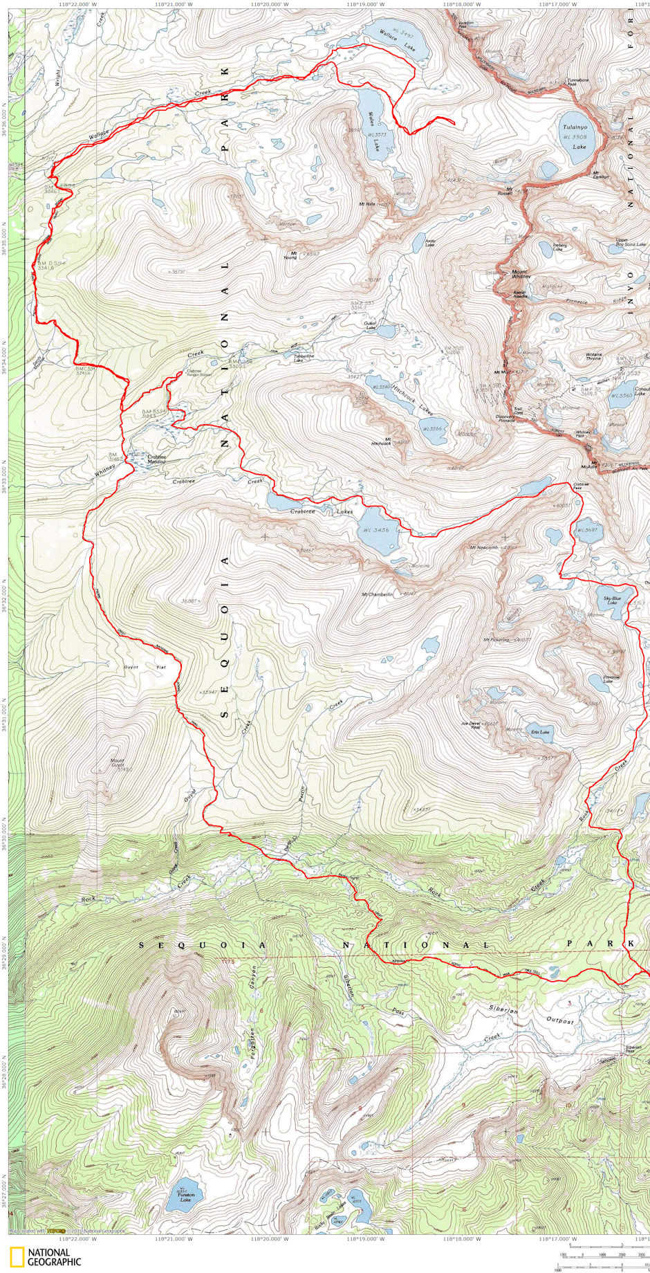
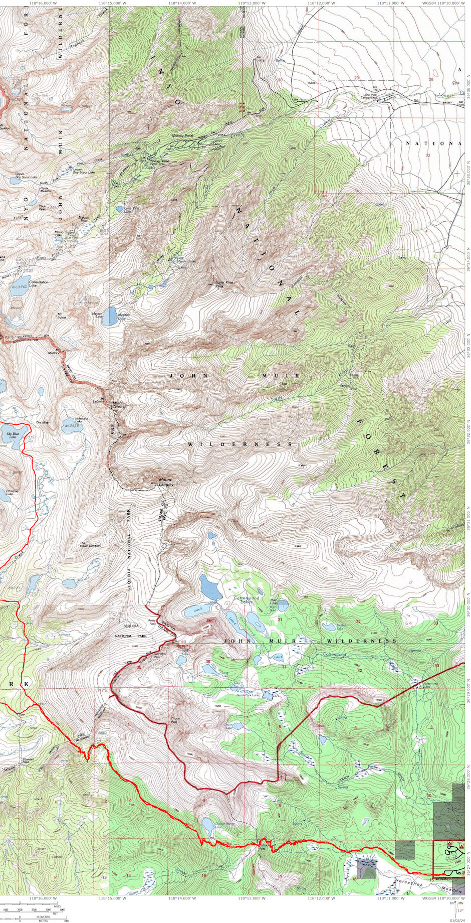
On September 2-9. 1979 I backpacked 59 miles in the Wallace Lake/Miter Basin area of the John Muir/Sequoia National Park Wilderness.
Sunday I drove to the trailhead at Cottonwood/Horseshoe Meadows and hit the trail about 9 a.m. Made Cottonwood Pass for lunch and headed on for the meadow just this side of the Sequoia National Park boundary. Found two flowing springs and nice campsite in meadow (edge). Was tired after long first day hike and heavy pack. Camped in bivouac sack.
It was frosty with thin ice on water bottle in the morning on Monday and I headed into the Park and followed the new Pacific Crest Trail down ridge - open forest, not particularly interesting and no views - old Siberian outpost trail route better. Dropped down near Siberian Creek but didn't look for campsites (appeared no problem to find though). Arrived at the main Rock Creek trail and headed down to creek crossing. Made camp about 1/4 mile downstream across meadow. Took "bath" in creek and sunned. Several deer came out in the meadows on both side of creek (saw 7).
Had now developed routine. Up about 8 a.m. Fix breakfast in tent and pack, hitting trail about 9:30. Make camp about 3 p.m. Wash and sun. Read mystery novel until about 7 p.m., then fix supper in tent, finishing about 8 when it got dark. Had full moon throughout the trip.
Tuesday, I headed over Guyot Pass to Crabtree Meadow. Newish trail up from Rock Creek is still steeper than normal new trail standards. Had lunch on pass and arrived at Crabtree Meadow about 3 p.m. Camped across creek in nice unused spot. Lots of ants and a chipmunk got into my pack during the night. Chased him out before too much damage. Thirteen deer including about half young ones came out in the meadow in early evening and ate, ignoring people camped around the meadow. Weather beautiful and warm - not a cloud in the sky (until last two days).
Wednesday I headed up the John Muir Trail to Wallace Creek, then up the creek to camp just below Wallace Lake at the same campsite (one with fish smoker) we had camped at the year before in bad weather. Took dip in the creek and sunned, enjoying perfect weather. No one camped nearby. (Some were camped at the lake I found out as they left next day.)
Thursday I hiked up to Wallace and Wales Lakes. Hiked up the route Gil had followed the year before to top of cliff on way to Tulainyo Lake. Enjoyed taking pictures and seeing the area in such good weather. Headed back to camp for lunch and then headed down Wallace Creek as a Sierra Club group came in. I had lucked out on being between two days with large groups of people.
At the Muir Trail I headed back toward Crabtree and made camp at a pond off the trail which I had checked out the day before. Found that the old trail used to go alongside the pond - probably did 20 years ago when I first hiked the route. There were several possible campsites and two well running springs. The lake was in an advanced stage of turning into a meadow with grass well out from all sides of the shore into the water. One lonely duck had settled on the pond for a rest and kept me company.
Friday I continued on the Muir Trail to the Crabtree Ranger Station for lunch (early) Talked to the Ranger who will be in until end of October. Followed creek down to the Crabtree Lake trail and headed up to the Lakes. Followed old unused section for a ways until ran into the current route.
One couple was camped below the lower lake at a pond, but no one else was in the area. Met man and girl who had come over from Miter Basin and were trying to find Bighorn Sheep to photograph. They went on to Arctic Lake to camp. I made camp on bench just above the ponds above the upper end of the lower Crabtree Lake (just below the upper lake). A heavy south wind had come up this morning and indicated a change in the weather. The Ranger said forecast was good for next couple days. A few clouds formed after I took a swim and sunned. Was breezy all night.
Saturday I headed up past Upper Crabtree Lake to the lake just below "McAdie Pass" to the Miter Basin. Very easy walking and beautiful scenery going up this valley. At the highest lake I started across the south side boulders. Two snowfields on the way could be a problem, but this year they had melted back "just enough" from the lake to allow careful passage along the lake shore boulders. Could have gone around the sandy north shore but would have been slow and tiring.
Near upper end of lake started up the boulder slope to the pass. No real problems other than work and choosing the least tiring route. Made the top for lunch. Was tired and enjoyed rest and views down both sides. Pass was not windy but you could hear it "moaning" on the nearby peaks.
As soon as I headed down the wind about blew me away. Had to carry my hat part of the time. I remembered from the time the Post 360 group did this route in 1971 that they had had trouble getting past the first lake due to a cliff at its bottom end - so, I followed occasional footprints, scattered ducks, and my own intuition well to the west over a ridge into the next drainage which I followed down to Sky Blue Lake with no difficulty and avoided a lot of up-and-down climbing.
It would be difficult to find your way up from the Miter Basin side if you didn't have prior knowledge of the terrain. Made it to Sky Blue Lake about 3 p.m. and the wind was really blowing. I decided not to camp here (campsites few and no shelter) and that I wanted to get far enough to be able to hike out to the road the next day - so, headed down past waterfalls and some campsites to the east into the broad Rock Creek valley. Made camp about a mile below the creek coming in from Primrose Lake at one of several campsites in a small grove of trees. It was slightly cloudy and cooler.
Sunday the clouds were already around as I got up and being anxious to get to the car I made an earlier than usual start, leaving at 8 a.m. I followed the "trail" down Rock Creek to the main Rock Creek trail coming in from Army Pass, then up and across to the Pacific Crest Trail and out over Cottonwood Pass to the car. It was a long 12+ mile day but not too bad with limited elevation gains. Made Cottonwood Pass just after noon for lunch and the car about 2:30.
This was a great trip for me as I got to see the Wallace Lakes under good weather conditions (.after last year's mess) and got to do the Crabtree/Miter Basin traverse which I had wanted to do since 1971. I got some good relaxation, lost some unneeded pounds and enjoyed great weather.

Wallace Lake/Miter Basin Deck Trek 1979 - West Half

Wallace Lake/Miter Basin Deck Trek 1979 - East Half
