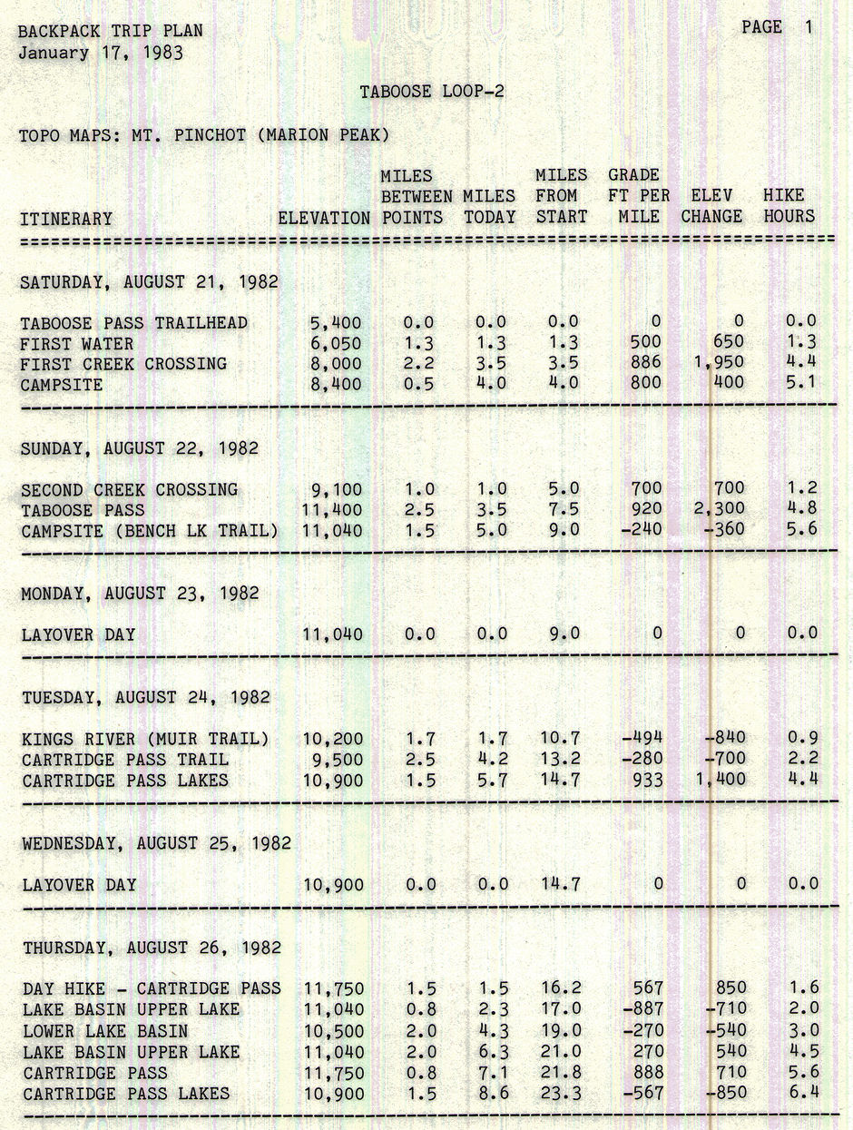
On August 21-29, 1982 I ended up going by myself on this trip which filled in an area I had longed wished to see. The Taboose Pass trail starts at 5400 feet with a mile of exposed desert at the start so I got up early and hit the trail before dawn. This is a steep trail all the way but I made the first water in fairly good shape despite a heavy pack.
As I continued up the trail I noticed that the Rabbit Brush was starting to give me hay fever problems which made the going even slower. Took a good rest at the first creek crossing and decided to camp at the next available place. The creek was running high and required wading but was no problem. At the top of the hill I found the campsite under the big tree vacant but it looked like a nicer camp with some privacy would be available to the south.
There was but it required a little bush whacking and climbing up over a very large fallen tree. The campsite had just enough room for the tent but had a clear running stream nearby. Icy delicious water and enough for a quick rinse off. As I took a nap it rained a little but soon cleared up.
Sunday I got a fairly early start - climbed back over the tree - and headed up the steep trail. Climbed the hill after the second creek crossing and stopped for lunch at the campsites there - the usual stopping point for most people. Continued up the steep trail to the pass which required crossing several snowfields. There was a cool breeze and rain was threatening as I topped the pass. Too threatening to stop and enjoy the pass.
Moved quickly down the trail and off toward Bench Lake looking for the spot I had camped at some years before. Missed that spot but found a nice campsite a little off the trail with protection and a stream. Shortly after camp was made it started to rain and did so much of the night as I remember. Being tired and with rainy weather I decided to layover a day and rest up. This turned out to be a good choice as it rained much of the day and I enjoyed the rest and did some reading.
Tuesday I headed back to the Taboose Pass trail and down toward the Kings River. Found a beautiful flowery meadow and several deer which became photo targets. On reaching the river I found the water running very high. Trail signs in the area are mostly non existent as the Taboose Pass trail is not maintained. Looked upstream for a crossing and found none that was safe so tried downstream. Found a split in the stream at a small island and waded across part of the river and used a log for part.
Had lunch and said hello to some John Muir Trail hikers as I located the old trail to Cartridge Pass. This little used trail was in fine shape as I hiked down it all by myself. Just before starting up to Cartridge Pass the trail crosses the stream twice to avoid a talus slope, however the talus is easy going so I crossed it to pick up the trail in a beautiful wooded area with many campsites.
The climb up toward Cartridge Pass is steep but the trail is not in really bad shape. It is in the trees most of the time but with the warm temperature and high humidity it was a hot climb. I did most of it in the nude as there were no people around and it felt good. I arrived at the lakes below Cartridge Pass in fine shape but ready for camp. It showered that afternoon after I made camp but I was busy enjoying a nap. Somewhere along the line I took a dip in the lake to wash off - felt great.
Wednesday I decided to layover and rest up. I sunned and read a book taking it easy. About noon another party of three stopped for lunch over by the lake outlet but I didn't talk to them. They went on up over the pass apparently.
Thursday I got an early start and did a day hike up over Cartridge Pass into Lake Basin and down almost to Marion Lake. I went far enough to tie in with the route we had taken in 1969 from Dumbell Lakes to Marion Lake. I could see Marion Lake from a nice view point. I saw no one else the entire day and hiked mostly in the nude which felt great. The temperature was just right and the bugs were minimal except in spots - not enough to be a real problem. Although steep in spots and not maintained, the trail over the pass is in relatively good shape and presents no problems. There was patchy snow on the north side.
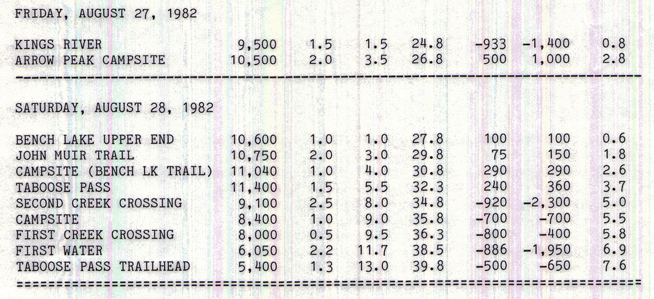
Friday I headed down the trail, again in the nude, and when I reached the river I headed downstream for a short distance (lots of campsites) and then waded across the river at a good spot. Plenty of water but being wider and flatter here it was no problem even though up to two feet deep. Dried my boots and had lunch before heading cross-country up the slope toward Arrow Peak - the area west of Bench Lake. By paying attention to the map and topography, avoiding rock cliffs, etc. it is easy to find a route up this slope.
I found evidence of a ducked route although I didn't follow it all the time. Even nude it was a warm climb but I enjoyed it. Made camp on a bench next to the Arrow Creek about 3 p.m. Took a dip in the creek to rinse off - even though it was glacier water it felt good. Got camp up just as it started to rain. Had two series of THUNDER storms that afternoon and evening. LIGHTNING was very close but presented no problems. Sounded like the Martians were landing. Quite a bit of rain fell but I was secure in my tent.
Saturday morning was cloudy but quiet as I headed cross-country toward Bench Lake. Saw my first people in three days camped at Bench Lake. They were packing up to leave - said it rained two inches that night. I headed on over to the Muir Trail and on toward Taboose Pass. Stopped for lunch at my campsite of a week previous and enjoyed blue sky and clouds over Taboose Pass. I happened to glance back west and found a black cloud heading up the Kings River canyon so headed out for the pass. The storm beat me to the pass and dumped hail on me as I crossed and started down the other side.
Again, no time to stop and enjoy the view. The storm let up as I descended the other side and the sun was soon out. I decided to head on out to the car. At the second creek crossing I ran into a teenager who had just finished the Muir Trail and was hiking up to get a cache of leftover food, etc. he had left on the Pass. His parents were backpacking up behind him and they would be camping in the area that night. I saw them about an hour later and advised them of the son's progress. I moved on down the trail and arrived at the car about 4 or 5 p.m. as I remember. It had been a pleasant trip in spite of the rain and I was now in trim shape. Too bad I'd have to go back to work.


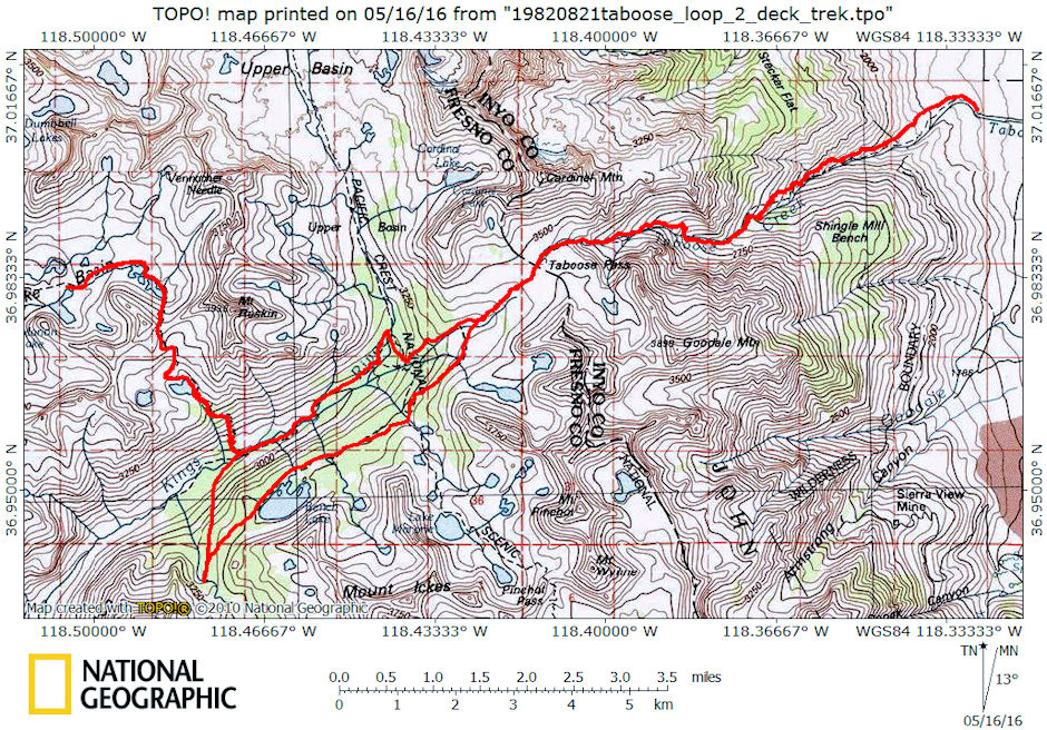
Cartridge Pass Route

Cartridge Pass Route Map
