On November 11, 1962 myself and the Lantz family set out to climb Martinez Peak but lost the trail so decided to drive to 8,000' Santa Rosa Peak and 8,716' Toro Peak on a ten mile round trip in the Santa Rosa Mountains.
The Santa Rosa Mountains are a short mountain range in the Peninsular Ranges system, located east of the Los Angeles Basin and northeast of the San Diego metropolitan area of southern California.
The Santa Rosa Mountains extend for approximately 30 miles along the western side of the Coachella Valley within Riverside, San Diego, and Imperial Counties. The range connects to the San Jacinto Mountains on its northern end, where the Pines to Palms Highway—California State Route 74, crosses them.
The highest peak in the range is 8,716' Toro Peak, located approximately 22 miles south of Palm Springs, just south of Route 74, and on the northeast side of Anza-Borrego's Upper Coyote Canyon. The Santa Rosa Mountains are also a Great Basin Divide landform for the Salton Sink Watershed on the east. Besides Toro Peak, other significant mountains in the range include Santa Rosa Peak/Mountain, Martinez Mountain in the north and Rabbit Peak in the south.
The oldest accounts of the southeastern reaches of the Santa Rosa Mountains survive from the 1774 Spanish expedition led by explorer Juan Bautista de Anza into colonial Las Californias through the Coachella Valley from the populated Viceroyalty of New Spain region (present day Mexico). 19th century maps of the region show the Santa Rosa's as a southern extension of the higher northern San Jacinto Mountains. The name "Santa Rosa Mountains" first came into use by the USGS in 1901.
Santa Rosa Peak/Mountain is an 8070' peak located 13 miles S/SW of Palm Desert, California. It is the sixth highest peak in Riverside County, and the second highest peak in the Santa Rosa Mountains. Despite these qualities, Santa Rosa Peak/Mountain has a rather diminutive prominence of 330', and is hopelessly outclassed by Toro Peak, just 2.3 miles to the southeast.
Santa Rosa Peak/Mountain, however, does have two distinct advantages over Toro Peak. The first advantage is near-drive-up access almost year round (assuming the appropriate gate is open). In the dead of winter the upper portion of road 7S02A can be covered with snow and ice, particularly on the north side of the ridge between Santa Rosa Peak/Mountain and Toro Peak. The portion of road 7S02A leading up towards Santa Rosa Peak/Mountain generally does not have this problem.
The second, and perhaps more important advantage of Santa Rosa Peak/Mountain, is that it can be accessed legally. While summiting Toro Peak requires trespassing on the Santa Rosa Indian Reservation, Santa Rosa Peak/Mountain resides on public land in the San Bernardino National Forest. It may be of little consolation to prominence peak baggers, but views from Santa Rosa Peak/Mountain are almost as good as Toro Peak's, and there are numerous locations on and near the summit for picnicking and camping.
Toro Peak is the highest mountain in the Santa Rosa Mountain Range. It is located 15 miles south of Palm Springs, 12 miles west of the Salton Sea, and 31 miles east of Temecula, in Riverside County.
Part of the mountain is under the jurisdiction of the San Bernardino National Forest. Another portion, including the 8,717' summit and the United States Geological Survey marker on the summit (registered in 1939), is gated and controlled by the Santa Rosa Indian Reservation. A third portion of the mountain is administered by the Santa Rosa and San Jacinto Mountains National Monument.
The mountain is accessible from California State Route 74 (also known as the Pines to Palms Highway) via a dirt road approximately 5 miles east of Route 74's junction with Route 371.
The dirt road begins at an elevation of 4,700 feet and heads towards the summit for approximately 13 miles. A 4x4 or off-road vehicle is recommended because the road is steep and rocky. It comes to a locked gate around 8,200 ft and from there it is a 500-foot hike to the summit up a rough maintenance road that passes the former MCI (now owned by Verizon Communications) primary power generator that provides electricity to the summit.
At the time we climbed it, the Indian Reservation wasn't making much of an effort to keep people off the peak on their private land. In recent years they have been a little more persistent.
From Toro Peak's summit one can see the Santa Rosa Mountain Range to Palm Springs, and neighboring mountains such as San Jacinto Peak, Mount San Gorgonio, Palomar Mountain, and Hot Springs Mountain. To the east/southeast, the Salton Sea and Imperial Valley are visible. From the peak in good weather Charleston Peak in Nevada is also visible.
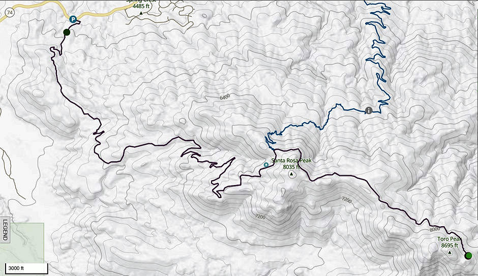
We drove almost to the top of Santa Rosa Peak/Mountain and then hiked 1/2 mile to the top where we saw a cabin and climbed a tree tower.
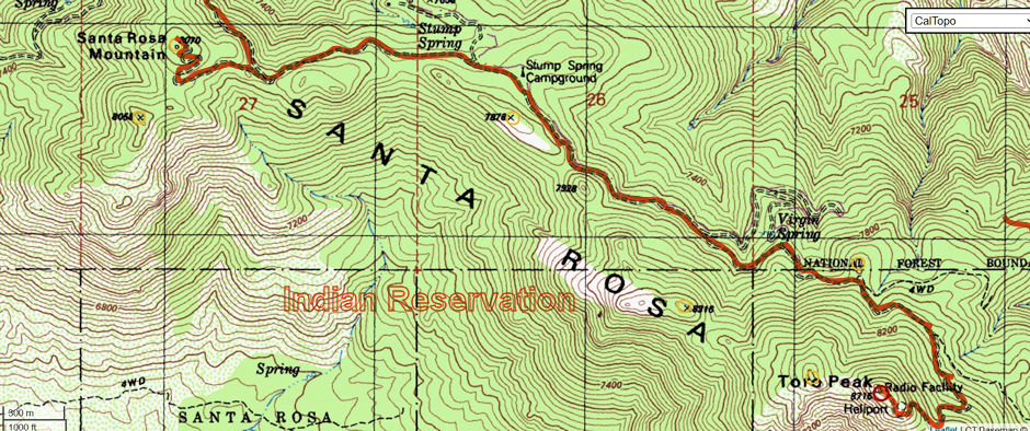
We then hiked to Toro Peak along the road on a beautiful day.

Route map for Santa Rosa Peak/Mountain and Toro Peak

Route between Santa Rosa Peak/Mountain and Toro Peak
