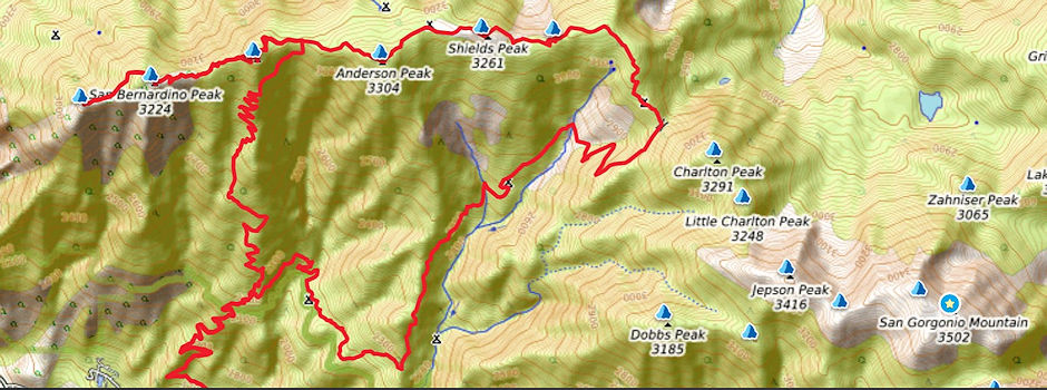
On August 12-13, 1961 myself with John Hoffman did a twenty mile round trip on the San Bernardino Ridge in the San Gorgonio Wilderness. We climbed four peaks which are part of the "9 Peaks Challenge"

San Bernardino Mountains Ridge
Shields Peak - 10,701' - at the western end of the San Bernardino Mountains. It is the fourth peak of nine in the popular San Bernardino Mountain Traverse culminating with San Gorgonio, Southern California's tallest peak at 11,502. All nine peaks are in excess of 10,000 feet in elevation. The traverse, the largest subalpine wilderness area south of the Sierra Nevada is typically completed in a multi-day backpacking trip. Many of the peaks can also be accessed via day hikes.
Andersen Peak - 10,864' - located in the heart of the San Gorgonio Wilderness Area in the San Bernardino Mountains in Southern California. At 10,840', it is the fifth highest peak in Southern California south of the Sierra Nevada, and one of seventeen peaks in the SGWA with an elevation of over 10,000'. It is the third peak, in a series of peaks, that lie west to east on the San Bernardino crest/ridge, starting with San Bernardino Peak at the western end and ending with Alto Diablo at the eastern end, before the ridge takes a dogleg southeast to continue on with Charlton Peak, Little Charlton, Jepson Peak, and Mount San Gorgonio, the highest point in Southern California.
East San Bernardino Peak - 10,691' - located within the San Gorgonio Wilderness on the western end of the San Bernardino Mountains. It is the second peak, in a series of peaks, that lie west to east on the San Bernardino crest/ridge, starting with San Bernardino Peak and ending with Mt. San Gorgonio, the highest point in Southern California. Many Hikers will bag this peak, along with the other peaks on the crest, while hiking the San Bernardino Mountain Traverse. This is normally done as a 2-3 day backpack. It can also be climbed as a moderate to strenuous day hike from at least 3 different trailheads. The views from the summit are stellar. One can see much of Southern California (on a clear day) as well as Mt. San Jacinto, Mt. San Gorgonio and Mt. Baldy.
See more information here.
San Bernardino Peak - 10,624' - together with its twin peak, San Gorgonio Mountain, just five miles away and 900 feet higher, anchors the western-most end of the San Bernardino Mountains. At 10,649 feet (3246 meters), San Bernardino Peak is quite a landmark. The higher slopes of San Bernardino Peak are beautiful and rugged subalpine terrain.
It was a steep 7 miles on the Forcee Creek Trail to Trail Fork Springs - good water. More info here. After rest we hiked to Shields and Anderson (3 mile total).
Sunday we hiked San Bernardino Peaks ridge trail to East and main San Bernardino Peaks, Limber Pine Springs (water), Manzinita Springs (dry) and Camp Angelus (10 miles). Temperature down to 43° - weather fine.
